
A spring storm that drenched Northern California brought light showers late Thursday into early Friday in parts of Southern California.
Most of the rain will fall overnight and wrap up by early Friday morning. Accumulations are expected to be light.
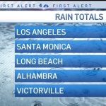
A look at rain totals for April 22, 2022.
Los Angeles received .33 inches by Friday morning. Other totals include .51 inches in Santa Monica; .13 in Long Beach; .60 in Alhambra; and .15 in Victorville.
A downpour at about midnight in Alhambra caused a partial roof collapse at a Target store. No injuries were reported.
Less than a quarter-inch of precipitation was expected before the storm moves out. In the mountains, as much as 2 inches of snow is possible at elevations above 6,000 feet.
“It happened overnight while you were sleeping,” said NBC4 forecaster Shanna Mendiola. “We have some clouds overhead. Those are going to clear out.”
Isolated snowfall is expected to taper off Friday morning.
In Orange County, Bee Canyon recorded .39 inches of rain as of 5 a.m. Lower Silverado Canyon reported .39 inches and Lake Forest reported .36 inches.
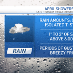
The forecast for April 21 and 22, 2022.
Some areas might see isolated thunderstorms, which can producer higher amounts.
“The rain pretty much wraps up before the Friday morning commute, but showers could linger in the mountains during the day,” said NBC4 forecaster Belen De Leon. “Friday will be breezy and cool.”
A warm-up begins this weekend with offshore winds developing. Some areas will reach 90 degress early next week.
Although the storm won’t bring much rain to Los Angeles, it produced heavy snow and rain in Northern California on Thursday. The spring storm added to late-season precipitation totals after a dry winter.
Winter storm warnings were in effect from the Oregon border and down through the southern Cascades and the northern Sierra Nevada.
Around the country, people rely on these piles of snow for their water supply. What is a snowpack, and how else does it impact you?
Chain controls were put into effect for vehicles on major Sierra highways and authorities discouraged mountain travel.
“Well it got nasty, and got nasty fast!!!” said a tweet by the California Highway Patrol office at Truckee on Interstate 80 north of Lake Tahoe.
Drivers were urged to bring warm clothing, food and water.
“You never know when you could get stuck in snow or long travel delays occur,” the Sacramento office of the National Weather Service wrote.
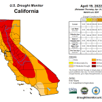
The U.S. Drought Monitor report for April 19, 2022.
The wet weather arrives after a dry winter left most of the state in severe or extreme drought. January through March was a particularly dismal stretch during what is usually the wettest time of the year in California.
Thursday’s update by the U.S. Drought Monitor showed wide swaths of the state in extreme or severe drought, but the report noted recent weeks of beneficial moisture.
The state’s mountain snowpack, a vital source of water, remains well below normal. The manual survey in the Lake Tahoe region April 1 recorded 2.5 inches of snow depth and a snow water equivalent of 1 inch, which is 4% of the April 1 average for the location.
The statewide snowpack average is 38% of average. That’s the lowest mark since the end of the last drought in 2015 and only the third time since 1988 that it’s been that low.