A strong low pressure system tracked from Nebraska northward into eastern South Dakota during the morning and afternoon on Memorial Day (May 30, 2022). An intense line of severe thunderstorms developed across eastern South Dakota in response, and then tracked northeast into western Minnesota. In addition to damaging straight-line winds and large hail, several fast-moving and/or rain-wrapped tornadoes were produced. The strongest tornado was rated an EF3 in Deuel County with an estimated peak wind speed of 140 mph after it destroyed a transmission tower. Additionally, heavy rains fell on already saturated soils across northeastern South Dakota and west central Minnesota.
Significant property and tree damage, power outages, river and overland flooding including across many county and secondary roads, and other impacts resulted across the same area that was hit hard by a derecho and tornadoes just two and a half weeks earlier on May 12th.
Seven tornado tracks have been confirmed, however the damage investigation continues. Information remains preliminary and subject to change.
Photos and summary information can be seen below or found at https://www.weather.gov/abr/ReviewMay302022.
Preliminary Tornadoes:
Tornado #1 – From 5 miles south of Goodwin to 1 mile north of Tunerville, SD
Deuel County
| Date |
5/30/2022 |
| Time (Local) |
2:46pm – 2:58pm |
| EF Rating |
EF3 |
| Est. Peak Winds |
140 mph |
| Path Length |
10.15 miles |
| Max Width |
100 yards |
| Injuries/Deaths |
0/0 |
| Summary: A grain bin was ripped from the base and tossed a mile to the northeast, a farmstead lost several outbuildings and sustained damage to the home, and a transmission tower was completely twisted and collapsed. |
Tornado #2 – From 8 miles NNE of Estelline to 2 miles SSE of Altamont, SD
Deuel County
| Date |
5/30/2022 |
| Time (Local) |
2:41pm – 2:53pm |
| EF Rating |
EF2 |
| Est. Peak Winds |
115 |
| Path Length |
11.9 miles |
| Max Width |
150 yards |
| Injuries/Deaths |
0/0 |
| Summary: A farmstead had one destroyed and one partially destroyed stave silo, a severely damaged barn, and a grain bin that was tossed a quarter mile to the northeast. At least 4 other farmsteads were damaged along the tornado’s path. |
Tornado #3– 3 miles WNW of Clear Lake, SD
Deuel County
| Date |
5/30/2022 |
| Time (Local) |
2:50pm – 2:50pm |
| EF Rating |
EF1 |
| Est. Peak Winds |
90 mph |
| Path Length |
0.43 miles |
| Max Width |
20 yards |
| Injuries/Deaths |
0/0 |
| Summary: A clear path was observed through a tree grove, and farm machinery was tossed. |
Tornado #4 – From 4 miles SSW of La Bolt to 4 miles NNW of Albee, SD
Grant County
| Date |
5/30/2022 |
| Time (Local) |
3:05pm – 3:10pm |
| EF Rating |
EF1 |
| Est. Peak Winds |
100 mph |
| Path Length |
10.31 miles |
| Max Width |
40 yards |
| Injuries/Deaths |
0/0 |
| Summary: A farmstead had a roof ripped off a barn, damage to a machine shed, a destroyed stave silo, and a dented grain bin; the home had debris pierced through walls, roof panels ripped off, and broken windows. Another residence had half a barn roof ripped off and tossed a quarter mile to the northeast. Power poles were snapped at the base. |
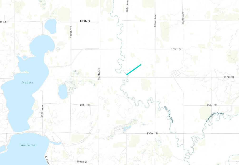
Tornado #5 – 4 miles ENE of of Stone Bridge, SD
Hamlin County
| Date |
5/30/2022 |
| Time (Local) |
2:30pm – 2:30pm |
| EF Rating |
EF0 |
| Est. Peak Winds |
85 mph |
| Path Length |
0.65 miles |
| Max Width |
10 yards |
| Injuries/Deaths |
0/0 |
| Summary: An eyewitness saw a brief tornado touchdown. Only minor damage to a cattle shed was noted. |
Track Map
 |
|
|
|
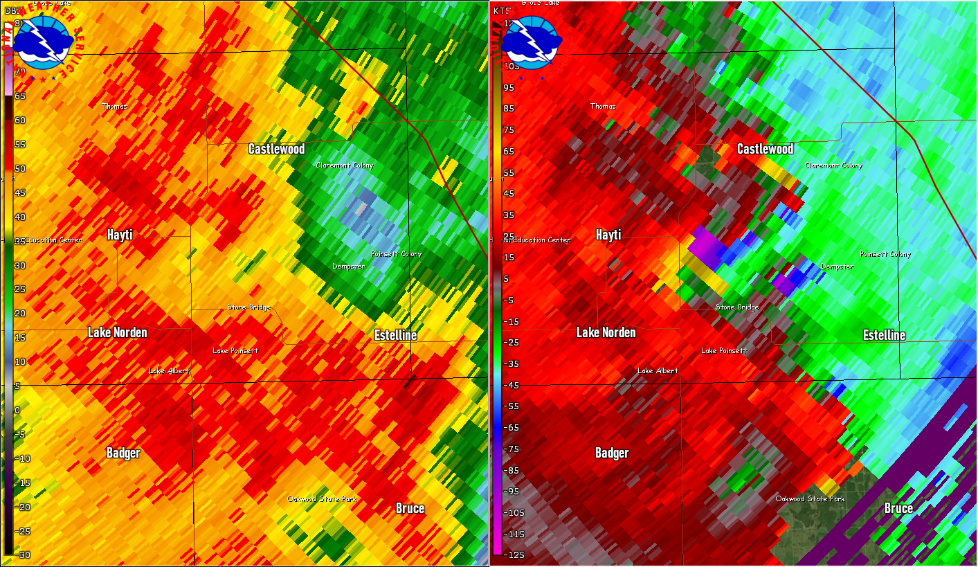
| Radar reflectivity (left) and storm-relative velocity (right) at 2:30pm |
|
|
|
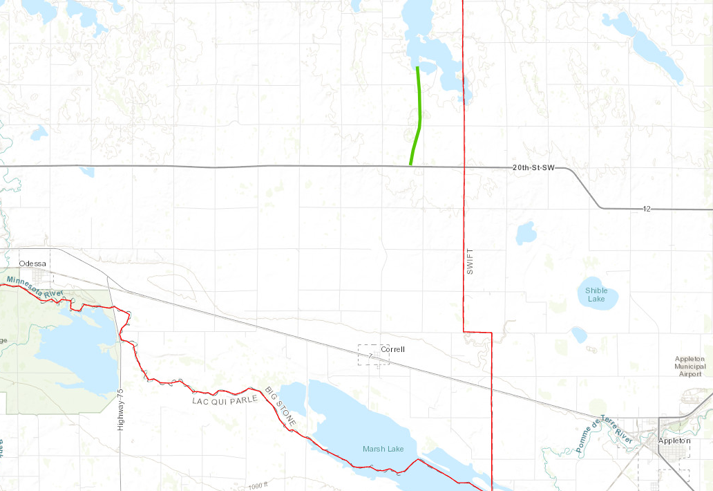
Tornado #6 – 4 miles south of Artichoke, MN
Big Stone County
| Date |
5/30/2022 |
| Time (Local) |
3:36pm – 3:38pm |
| EF Rating |
EF1 |
| Est. Peak Winds |
90 mph |
| Path Length |
2.41 miles |
| Max Width |
30 yards |
| Injuries/Deaths |
0/0 |
| Summary: A storm chaser documented the brief tornado touchdown. Two farmsteads were damaged. |
Track Map
 |
|
|
|
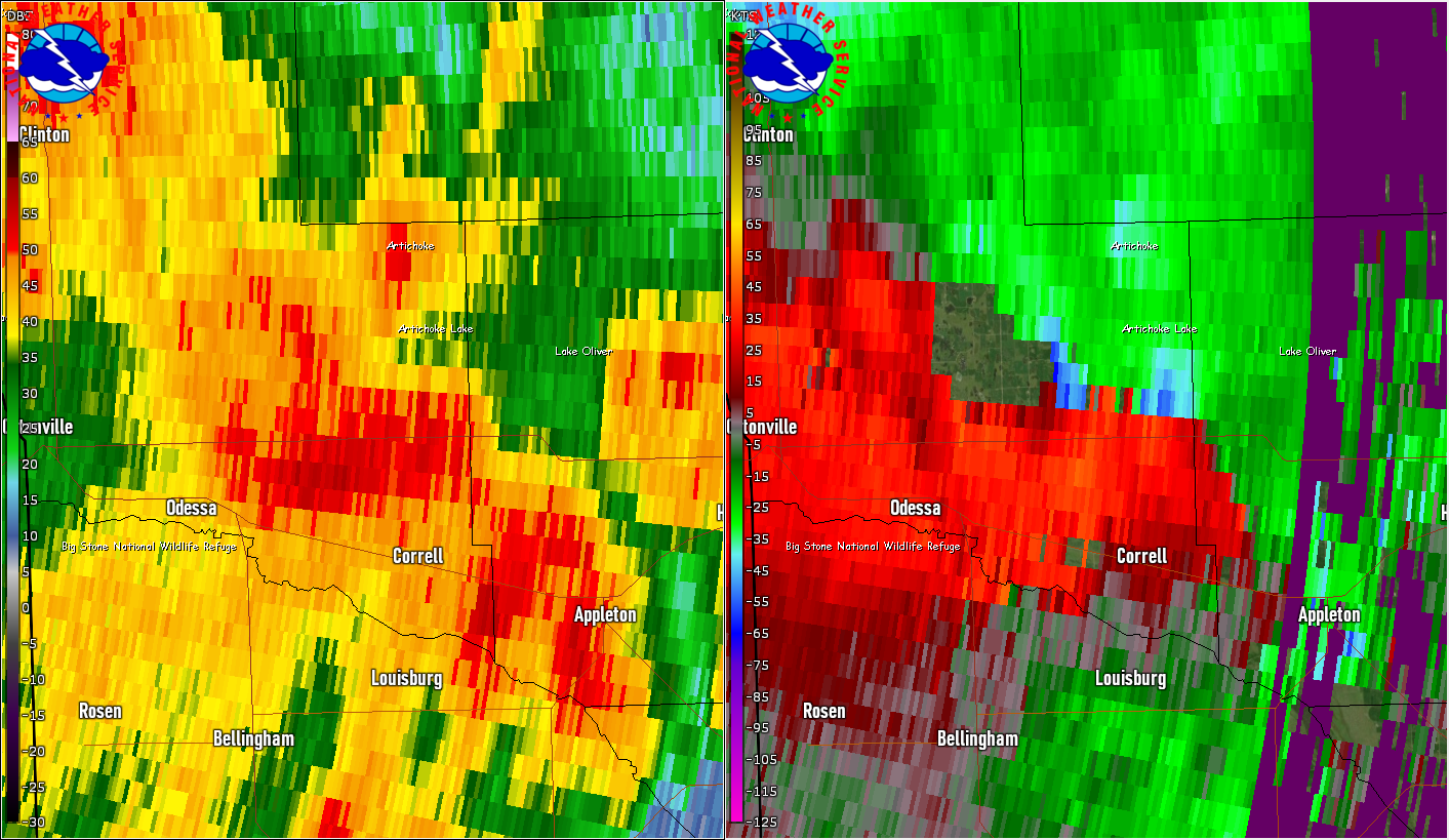
| Radar reflectivity (left) and storm-relative velocity (right) at 3:38pm |
|
|
|
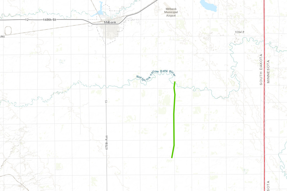
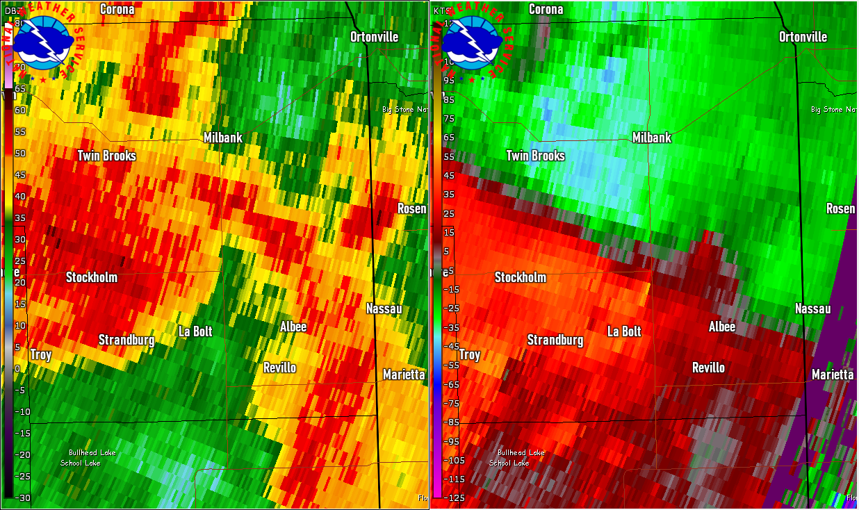
Tornado #7 – From 4 miles north of Albee to 5 miles SE of Milbank, SD
Grant County
| Date |
5/30/2022 |
| Time (Local) |
3:10pm – 3:14pm |
| EF Rating |
EF1 |
| Est. Peak Winds |
100 mph |
| Path Length |
4.45 miles |
| Max Width |
20 yards |
| Injuries/Deaths |
0/0 |
| Summary: The tornado mangled trees, snapped and uprooted trees, damaged a dairy barn, and tore off a quarter of the roof of a house. |
Track Map
 |
|
|
|
| Radar reflectivity (left) and storm-relative velocity (right) at 3:12pm |
|
|
|
|
The Enhanced Fujita (EF) Scale classifies tornadoes into the following categories:
EF0
Weak
65-85 mph |
EF1
Moderate
86-110 mph |
EF2
Significant
111-135 mph |
EF3
Severe
136-165 mph |
EF4
Extreme
166-200 mph |
EF5
Catastrophic
200+ mph |
 |
