
It’s more Michigan spring in April for this week: First snow, then rain, a little sunshine and a big surge of warmth.
Interstate 75’s northbound lanes at Grange Hall in Oakland County were closed early Tuesday for about an hour and a half due to icy conditions, after widespread snow and rain Monday. Other crashes north of Detroit, including along Eight Mile in Southfield, kept emergency crews busy.
Monday
Snow didn’t reach peak forecast totals of up to 4 inches in Metro Detroit and 6 inches in the Thumb area, after dry air surged into the region later Monday, according to the National Weather Service. But for a while, the snow was coming down thick and fast across southeast Michigan.
Lansing recorded less than half an inch of snow. About 2.5 inches was recorded in Highland, and 3.3 inches in Lake Orion. Troy recorded just over 2 inches. Port Huron and Lexington saw nearly 3.5 inches. About 2 inches fell in Detroit.
Tuesday
Temperatures will still be around 20 degrees below normal, and it will be breezy. The weather service says temperatures will remain in the mid-40s with up to 30 mph winds and showers/snow flurries are possible this morning.
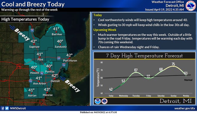
Wednesday
Sunshine will be abundant around the region.
“Full sunshine should get temperatures into the 50s which is still some 5 to 10 degrees below normal,” the weather service says, but the warming temperatures are a sign of things to come.
Thursday
Showers return Wednesday overnight into Thursday morning. But temperatures for southeast Michigan will be solidly into the 60s, with some areas approaching 70 degrees despite the widespread rain.
Friday
Temperatures will be a little cooler than Thursday but, according to the weather service, “the stage will then be set for a warm front to begin working back northward late Friday.”
And by the weekend, it could get hot.
For Saturday, the National Weather Service says, “easy middle to upper 70s for daytime temperatures with some possibility that 80 could be reached (by Sunday).”