
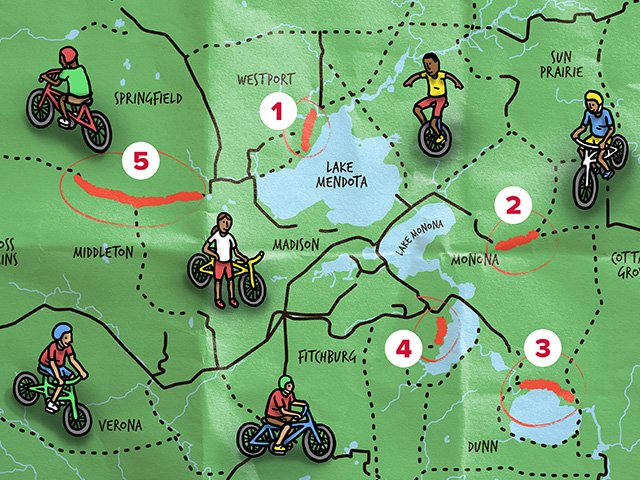
The bike trails, existing and proposed, on the 2018-2023 Dane County Parks and Open Space Plan form an enticing web, avenues of adventure crisscrossing the county. Solid lines represent completed trails; dotted lines, trails yet to come.
And while it seems from the map that new bike trails must be popping up everywhere, Chris James, senior landscape architect for Dane County, says that right now only five of the dotted lines are close to getting underway.
“I wish I could have them all done by tomorrow,” James says. But there are challenges that make the projects slow going.
Dane County has more than 100 miles of bike trail, and while the segments that are currently on the front burner will add only about five miles to the network overall, they provide key connections between completed segments. In picking which trails to prioritize, the parks department first tries to “fill in those pieces that are going to make a big impact,” says James.
Overall, the strategy is to prioritize trail routes that provide both recreation and transportation: “If a trail provides a useful alternative transportation route, it is more likely to “bubble up to the top.”
One of the trails under construction will extend the North Mendota Trail through Governor Nelson State Park. The North Mendota trail will ultimately allow cyclists riding around Lake Mendota to avoid the shoulder of busy County Highway M.
The segment, slated to be completed by July, will run from North Shore Bay Drive on the east side of the park, head west through the park and under M to a new subdivision, The Farm at Bishops Bay.
Waunakee is connected to the state park via bike lanes and the recently completed boardwalk from Woodland Drive, across Six Mile Creek, to North Shore Bay Drive. The next phase will take the trail from Bishops Bay to the city of Middleton, mostly along County Highway M.
Perhaps the highest profile project underway is connecting the Capital City Trail on the east side of Madison to the Glacial Drumlin State Trail, which runs from Cottage Grove to Waukesha.
This is a connector that has been in the works for “decades,” says James. “It’s such a small gap, about five and a half miles,” from the outskirts of Madison to the trailhead in Cottage Grove. That stretch is the last missing piece in a trail network that will run from Dodgeville to Milwaukee. But it’s a piece that’s been difficult.
A short but crucial segment called “Phase One,” from Wagon Trail Road in the city of Madison (just west of I-39/90), under the Interstate along an existing rail corridor, and east through farmland to Buckeye Road at Fankhauser Road, “has been stalled out for literally decades,” James explains, “because the railroad right-of-way is so narrow underneath the Interstate.”
But a deal with D.O.T., the DNR, the city and the railroad is at last in the works, and James is “cautiously optimistic” that it will finally get Phase One past the bottleneck. Even when that happens, though, design and engineering for the trail would still need to be completed, so construction couldn’t start until two years from now. And there will still be four miles from Buckeye Road to Cottage Grove to be constructed.
Some of that land has already been acquired. “There’s still one spot closer to Cottage Grove that we’re trying to work through,” James says. But he is optimistic that those pieces will move ahead.
Fans of area bike trails are likely familiar with the completed segment of the Lower Yahara River Trail, which rolls through William G. Lunney Lake Farm County Park and over the Yahara River, running from the Capital City Trail to McFarland — via what is the longest inland boardwalk bridge constructed solely for non-motorized transportation in North America, at nearly a mile in length. It is not just a shortcut between McFarland and Madison, but a beautiful one.
The Lower Yahara River Trail will eventually run from McFarland to Lake Kegonsa State Park on the north shore of the lake, making it possible for Madison residents to bicycle to Lake Kegonsa without riding narrow country roads.
Work on the next segment, from Fish Camp County Park along the eastern shoreline of Lake Kegonsa to the state park, is “a pretty significant piece of trail in the regional trail system,” James says. Like the segment bridging Lake Farm park with McFarland, this stretch will require boardwalk over marsh and Door Creek, creating a path that currently doesn’t exist at all. Right now the only way to get from Fish Camp to the state park is a long U-shaped detour north and then south again to skirt wetlands.
James is hopeful that Phase Two will be bid out this summer and construction could start as soon as this coming winter. He’s also optimistic because “once we have these tough pieces put in place, the rest of them will follow much easier.”
In addition to the challenges of building boardwalk over wetlands, James notes that the long history of human habitation in this area means there are significant archaeological sites like Native American mounds in the area. “We have to do a lot of planning and review to make sure that the trail isn’t impacting those.”
Fish Camp County Park has a modern history as a site for carp seining, and the lower Yahara has been a site of fishing for thousands of years.
Dane County is “lucky to have so many cultural resources. But we have to be sensitive to them and avoiding them is not always easy, and it’s not cheap, but it’s something we feel very strongly that we need to do,” says James.
Another path is close to reaching the construction phase; it will connect the Lower Yahara River Trail at Lake Farm County Park to Waucheeta Trail, through state-owned land to residential streets along the west shore of Lake Waubesa and Goodland County Park. The land is part of what will become Capital Springs Centennial State Park.
While not as far along as the other trails mentioned, another pathway that James cites as “high on our radar” is the Black Earth Creek Trail, from Middleton to Mazomanie, and then from Mazo to Sauk City along the Wisconsin River and County Highway Y. Sauk County, James notes, is “really moving along” on connecting Sauk City to Devil’s Lake via bike trail, and also connecting that to Reedsburg and the 400 State Trail. “You can just imagine how popular a trail would be that hooked up from Madison and eventually to Devil’s Lake State Park,” says James. “That would just be off-the-charts popular.”