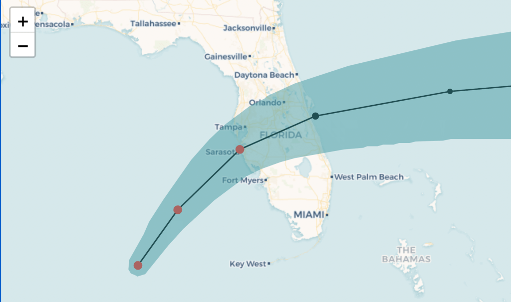

Hurricane Milton is expected to make landfall just after midnight Thursday near Sarasota on Florida’s Gulf coast as a large and dangerous storm, and it will retain hurricane strength for its entire track across the state to the east coast. But forecasters warned that devastating effects will spread well north and south of the exactly landfall location.
After days of shifting forecast tracks, models have settled on a region within 40 miles north ofr south Sarasota. Tampa Bay, where a direct hit would bring catastrophic storm surge, is not out of the woods.
As of Wednesday morning, Milton was still a Category 5 hurricane with wind speeds of 160 mph. Some weakening is expected in the next 12 hours as the storm hits wind sheer, but it will likely be too late to spare the region from a major landfall.
The forecast cone of uncertainty stretches from Tarpon Springs in Pinellas County south to Port Charlotte in Charlotte County. Forecasters warned residents along nearly the entire Gulf coast to have their hurricane survival plans finished within hours or to evacuate if instructed by officials to do so. Wherever the storm hits, it will produce a nearly unsurvivable storm surge of over 10 feet.
After landfall, the forecast shows Milton tracking parallel to Interstate 4 toward Orlando, and exiting the east coast somewhere between Port Orange and Port St. Lucie. A hurricane warning extends across the entire central part of the state from the west to east coasts.
Regardless of where the storm hits directly, much of the central portion of Florida is at risk of flash flooding, destructive wind and possible tornadoes.
Here’s the latest forecast track: