After many spots woke up with a fresh 1-2″ coating of snow Saturday morning, much of that has begun to melt and it will be completely gone Sunday. That’s because more warmth is on the way and Sunday is not the warmest of the next week. We’ll be making a run with a few 60°+ days and one day with 70° potential. That will also come with a “spring-like” severe storm potential that we’ve been tracking for a few days.
Snow to melt, snowfall deficit to continue
Below are the highest snow totals from the late Friday-early Saturday snow. It wasn’t a big snowmaker but it was right on the forecast. Highest totals were 1-2″, mainly across our north and northeast counties. Indianapolis officially received 0.1″ of snow, bringing our monthly snow to 4.0″. For the season, Indianapolis has 8.2″ under its belt. That’s 13.2″ below normal and the deficit will continue.


I should also note that Meteorological Winter ends Thursday. It will likely end as one of the warmest on record. This February (through February 23) is a top-10 all-time warmest and it will likely end in that territory, too. Absolutely nuts!


Warming up, turning stormy midweek
Highs Sunday will get well into the 50s, with several 60° readings being possible. It will also be sunny. Those temperature readings are thanks to the breezy warm southerly winds that will be around. That’s only the beginning of the warm-up! Mid-to-upper 60s Monday (Forecast: 68° would tie the record) and potentially hitting 70° Tuesday (Forecast: 73°, just shy of the record) ahead of a powerful cold front.
Big-time warm air advection will make it breezy and unseasonably warm through Tuesday. It will make it feel like Spring out there. That also means the warmer temperatures will also come with more moisture in the atmosphere.


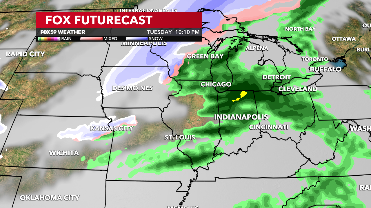
Rain chances go up later Monday and continue into Tuesday. It will start spotty with more widespread action on Tuesday. Some of that action could turn into thunderstorms. With the unseasonable warmth and moisture-filled atmosphere, some of those storms could turn severe. It’s also likely the Storm Prediction Center will put parts of the Midwest, including Central Indiana possibly under some level of severe risk. See below.

This is not a slam dunk just yet. Confidence is increasing that a severe potential exists for Tuesday’s storms. There will also be a heavy rain threat. However, lots of uncertainties remain this far out. You bet we’ll be monitoring this as we get closer. But expect things to potentially get noisy later Tuesday.
Post-cold front temperature drop and back-end snow?
The storms that arrive with a cold front late Tuesday into Wednesday may pack a punch. However, the other big thing from this is the steep temperature drop that follows the front’s passage. “Highs” Wednesday will be in the 50s but that will likely be around Midnight. That’s because once the front passes, temperatures will crash quickly. It will be much colder with temperatures in the afternoon in the upper 30s to lower 40s. This will be all dependent on timing.

But the “post-storm cool down” looks to be brief once again. February 2024 will end cold but March will start mild with highs in the 50s and 60s for March’s opening days. Stay up-to-date with the forecast in the days ahead, especially for Tuesday. Otherwise, we’ll all be on a roller coaster ride with temperatures this week!


