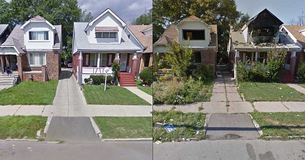
A social media post showing the dramatic deterioration of a Detroit block is making the rounds on Facebook, garnering hundreds of shares and comments.
The photos show nicely manicured properties in 2009 that have become overgrown with weeds and damaged by fire by 2013 — a stunning downfall in just a five-year span.
The comments have the sort of political undertones one might expect from a viral Facebook post, with Democrats and Republicans blaming each other. Some even accused the photo of being a fake generated by AI, underscoring just how unreliable social media has become in recent years.
Others noted that plenty of neighborhoods in the city have seen improvements since then, too. “Post the address. I’ll show you it today!” one commenter wrote. “Detroit has rebounded greatly in the last 10 years. My guess is those houses are beautiful today.”
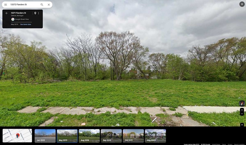
Metro Times was able to determine that the photo was taken on Flanders Street, between Coplin and Newport. We then looked up the address on Google Maps and clicked on Street View, where you can then toggle by year.
We can confirm that unfortunately, the post is accurate. In fact, between 2013 and 2018, the homes were completely demolished. An empty lot sits there now.
Detroit was hit hard during the Great Recession from 2007 to 2009, losing a significant portion of its population around that time. The city had about 848,400 residents in 2007, plummeting 16% to 711,200 in 2010, according to the census. The city has around 631,524 residents today.
In 2013, Detroit filed for municipal bankruptcy and Mayor Mike Duggan was elected, pledging to fight blight and revitalize the city. In the decade since Duggan became mayor, Detroit says it has demolished more than 20,000 blighted homes.
On the block where Flanders Street sits, about 30 of 40 lots are vacant and owned by the Detroit Land Bank Authority, with 17 of the lots demolished by the city between 2014 and 2023. Most of the demolitions took place in 2017 primarily using funding from Proposition N or federal Hardest Hit Funds. (Thanks to Koby Levin of Outlier Media for the research assistance.)
Duggan is also pursuing a novel plan for some of the city’s newly vacant lots. In July, Detroit City Council approved Duggan’s “Solar Neighborhoods” program, which aims to transform blighted lots across the city into 100 acres of solar farms. The plan is that eventually these solar farms will generate enough green energy to offset the electricity used by all 127 city municipal buildings. One of those solar neighborhoods is near the Flanders Street block, on the west side of Gratiot Avenue.
“Detroit can take real action to fight climate change and address some of the worst blight in the City,” Mayor Duggan said announcing the plan. “Detroit is now becoming the center of Michigan’s fight to address climate change.”
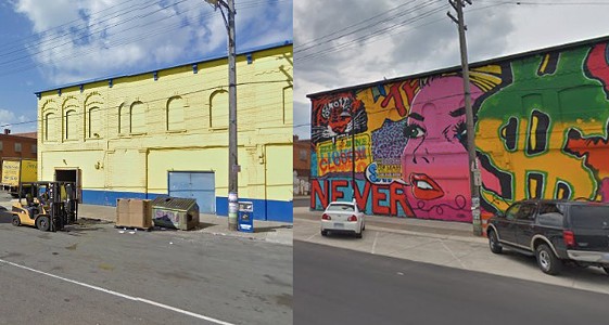
Of course, there are other neighborhoods in Detroit that show the reverse pattern as what we have seen on Flanders Street — notably in downtown and Midtown, which have both seen massive redevelopment projects in the past 15 years or so. Long a symbol of Detroit’s decay, the former Michigan Central Station was recently rehabilitated into a mixed-use space by Ford Motor Co., to the tune of nearly $1 billion.
Detroit’s rejuvenated downtown, which is now brimming with offices, shops, and restaurants, is a large reason Mayor Duggan has cruised to re-election for a third term — making him the longest-serving mayor in the city’s history following Mayor Coleman A. Young.
While Detroit is still struggling with curbing its population loss, there’s always more to the story of a viral Facebook post.
This article was updated with additional information about the demolitions.


