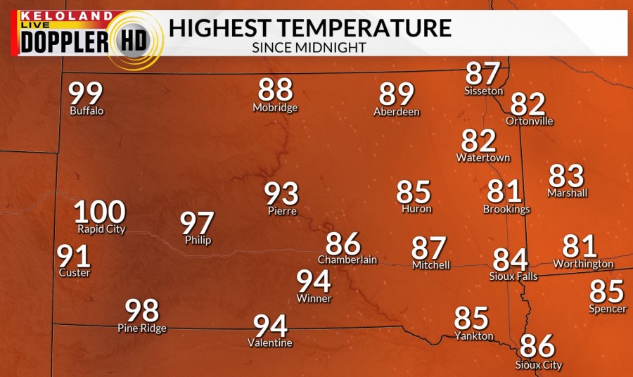
SIOUX FALLS, S.D. (KELO) — There has been hazy sunshine today. The wind has stayed mostly light. It has also been a hot day around the area. Afternoon temperatures have hit 100° in Rapid City, with several other places getting close.

There is a chance of thunderstorms as we head through the afternoon and evening in central and western South Dakota. Strong winds and small hail will be the main threats.

Otherwise for tonight we will have mostly clear skies. The wind will be light. Low temperatures will be mild, the mid 60s to low 70s.

There are a couple chances for rain and thunderstorms tomorrow. There is a level 2 of 5 risk in north central and northeastern KELOLAND of severe weather. Strong winds and small hail will be the main threats. The thunderstorms, if they pop up, will be isolated.

Tomorrow will be mostly sunny. The wind will be mostly light. Eastern KELOLAND will be humid. High temperatures will be in the 90s and low 100s.

There is a Heat Advisory in place in the southern portions of KELOALND for tomorrow afternoon through Sunday evening. More of KELOLAND could be added to this advisory. This advisory means the air will feel over 100.

Here is a preview of those heat index values. That takes into account the heat and humidity and gives us an idea what the air will feel like. Most of KELOLAND will feel like it’s in the 100s.

Sunday will be much like Saturday. High temperatures will be in the 90s to low 100s. There will be mostly sunny skies. The wind will be light. The humidity will stick around as well.

There is a chance of rain and thunderstorms moving into the area through the first part of next week. That will help cool things down, back to near and below normal by the middle to end of next week across KELOLAND.
