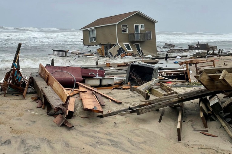
Rising sea levels contributed to this house collapsing on the shoreline in Rodanthe, North Carolina, during a storm last year.Credit: National Park Service/AP/Shutterstock
More than half of US coastal communities are underestimating the rise in sea levels that global warming might cause in their regions, according to a study. In what they call a first-of-its-kind analysis, researchers reviewed dozens of documents — the current assessments of sea-level rise for more than 50 coastal locations — and found that many of the predictions had gaps, including not considering worst-case scenarios. They reported their findings on 23 January in Earth’s Future1.
Climate change is hitting the planet faster than scientists originally thought
Increases in sea level pose threats such as flooding and land erosion for people in coastal areas. City planners, policymakers and other stakeholders use projections of how high Earth’s oceans will rise over decades to help guide decision-making about a variety of projects, including the construction of city parks, buildings and roads. But if communities do not account for scenarios that are considered unlikely but that could be particularly damaging, the infrastructure of these regions, and the individuals who live there, could be at risk, researchers say.
“It’s not often that we see studies that look at how science is being used within decision-making,” says Siddharth Narayan, a civil and coastal engineer at East Carolina University in Greenville, North Carolina. “This is a really interesting look at how this varies across the US.”
Gaps in knowledge
“Planning for future sea-level rise is difficult,” says Andra Garner, a climate scientist at Rowan University in Glassboro, New Jersey, and a co-author of the study. Many variables must be considered to predict the extent to which water levels will increase. Some rise is inevitable, given that Earth’s temperature has already risen by around 1.1 ℃ compared with pre-industrial levels, thawing permafrost and melting ice sheets. Sea levels have responded by rising by about 20 centimetres in the past century. But some variables hinge on future greenhouse-gas emissions, which depend on the climate actions that governments take, and are therefore harder to predict.
Arctic sea ice hits second-lowest level on record
Climate researchers regularly model future sea-level rise, continually updating their estimates on the basis of the latest data and science. These predictions are available to regional officials through technical reports such as those from the United Nations Intergovernmental Panel on Climate Change (IPCC). Sometimes, communities adapt the latest projections to incorporate factors unique to their regions — such as land subsidence, a process in which the ground gradually sinks.
Garner and her colleagues wanted to see how the latest science is making its way into local guidance documents. So they analysed nearly 400 projections of sea-level rise included in the assessments from 54 coastal locations in the United States, and compared them with regional estimates in the IPCC’s sixth assessment report, released in 2021 — one of the most comprehensive summaries of climate science so far. Sea-level projections from at least 56% of the communities included in the analysis did not reflect the upper range of the IPCC’s predicted rise by 2100.
IPCC climate report: Earth is warmer than it’s been in 125,000 years
In some cases, this was because the communities’ assessments used only a single, middle-of-the-road estimate for sea-level rise, instead of a range that accounts for worst-case scenarios. Not considering these scenarios means that infrastructure could be vulnerable to less likely, but more extreme hazards, and might require costly retrofits to continue functioning, Garner says.
The team also found that some communities had no locally developed guidance documents.
Garner and her colleagues discovered that some assessments — in particular, those for southern states — didn’t include predictions beyond 2100. If planners don’t look further ahead, Garner says, they cannot predict how sea levels might affect projects with long lifespans. One example is the construction of hospitals, which are crucial to public health and will “hopefully last at least 100 years or longer,” she says.
Risk tolerance
Assessing the full range of projections and timescales is beneficial because different projects have different risk tolerances, says Peter Ruggiero, principal investigator and co-director of the Cascadia Coastline and Peoples Hazards Research Hub, a network of scientists in Washington, Oregon and northern California funded by the US National Science Foundation. Garner explains that a power station near the coast, for example, would have a lower risk tolerance than a project such as a city park, because the power station would be likely to sustain greater damage from additional sea-level rise. Projects with a low risk tolerance therefore benefit from considering less probable — but more damaging — scenarios.
Garner says that the 2021 IPCC report is the first of its kind to be widely available in a user-friendly format, and she hopes that this will encourage more communities to use its data for future planning. Some coastal regions are keeping pace with current science, she adds, and those areas could serve as models to help improve assessments in all locations.


