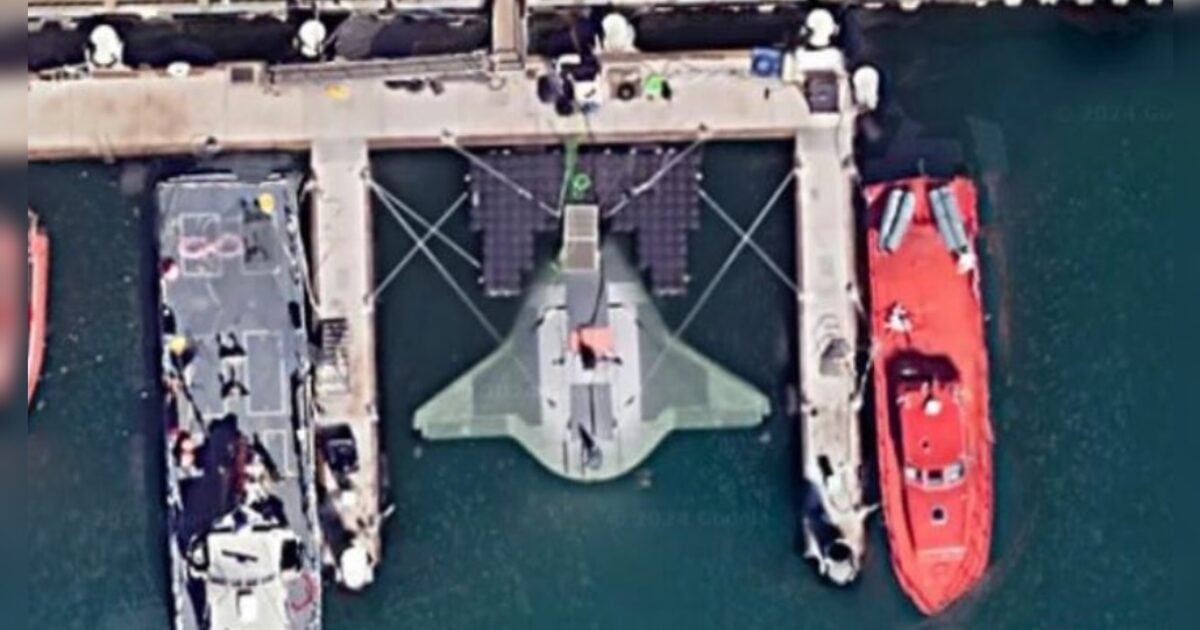

A top-secret U.S. underwater drone called the “Manta Ray” has been discovered on Google Maps.
Satellite photos on Google Earth show the Manta Ray docked at the Port Hueneme naval base in California.
As The Gateway Pundit previously reported, the Defense Advanced Research Projects Agency (DARPA) tapped defense contractor Northrop Grumman to create a prototype of the Manta Ray.
According to DARPA’s site, the Manta Ray seeks “to demonstrate innovative technologies allowing payload-capable autonomous unmanned underwater vehicles (UUVs) to operate on long-duration, long-range missions in ocean environments without the need for on-site human logistics.”
LOOK:
Someone managed to find the DARPA Manta Ray on google maps
Coordinates
34°09’12″N 119°12’31″W pic.twitter.com/uMdDj2dMsO— nikola 3 (@ronin19217435) June 20, 2024
Per The New York Post:
A top-secret US submarine prototype weapon called “Manta Ray” has been spotted by eagle-eyed Google Maps users and remains plainly visible to the internet public.
Satellite photos showing the “Star Wars”-looking vessel docked at Port Hueneme naval base in California went viral Sunday, its unmistakable profile standing out in stark contrast to its dockmates.
The smooth-looking autonomous vessel was named after the sea creature for its slick design and its ability to anchor itself deep underwater while operating in low-power mode.
Produced by Northrop Grumman as part of a US Navy project to develop long-range underwater weapons, Manta Ray is a sophisticated underwater drone capable of hibernating on the sea floor for “very long periods” without refueling.
Northrop Gruman finished creating the Manta Ray in April.
Together with @DARPA & our industry partners, we have built Manta Ray – a new type of uncrewed underwater vehicle. Manta Ray will operate long-duration, long-range missions in ocean environments, going where humans can’t. https://t.co/VbpZrx26Uh #DefiningPossible #SAS2024 pic.twitter.com/2vgJcKWu5W
— Northrop Grumman (@northropgrumman) April 8, 2024
Here’s what it would look like in action:
A fish-like robot that #autonomously roams the #oceans on long-duration missions, harvesting #energy to power its trek: That’s the goal the Manta Ray project. Learn more from @DARPA and @SandiaLabs in this Voices from DARPA podcast. https://t.co/oKtboC7YpN pic.twitter.com/DYj7Y7lWQg
— DARPA (@DARPA) October 20, 2022