For the third time in 13 months, a hurricane is churning through the Gulf of Mexico on a collision course with Florida’s northwest coast, threatening a region still recovering from recent extreme weather with historic storm surge and dangerous winds stretching across hundreds of miles.
But Hurricane Helene, which follows last year’s Hurricane Idalia and last month’s Hurricane Debby, is no ordinary storm, even by Florida’s standards. Like other high-profile climate-fueled storms of the last few years, it’s expected to undergo what meteorologists call “rapid intensification,” gaining strength at a phenomenal pace as it passes through the exceptionally warm waters of the Gulf. As a result, it’s poised to make landfall as a Category 3 or 4 storm just days after first forming in the Caribbean. It has also ballooned to become one of the widest storms on record, which will allow it to bring life-threatening winds and rain as far inland as Tennessee.
Hope Webb, a real estate broker who lives in a beachfront area of the state’s sparsely populated Big Bend region, said on Thursday that she was hunkering down and hoping for the best as the storm was projected to make landfall that evening.
“I am a lifelong resident of this area,” she told Grist. “I’ve weathered many a storm. I have faith God has his arms around us. But this storm is definitely testing our strength.”
Three factors conspired to make Helene a particularly potent storm. Like any hurricane, its fuel is warm ocean water, which injects energy into the atmosphere as it evaporates. As Helene moved through the Caribbean Sea, it fed on exceptionally warm ocean temperatures made at least 300 times more likely by climate change, according to experts. As it continued its march north to the Gulf Coast, it gathered strength from water that’s both unusually warm and deep — a great big pool of high-octane fuel.
In addition, the region’s wind shear — a term referring to the tendency of winds to move in varied directions and speeds at different elevations — has been low. That atmospheric messiness would typically put a lower ceiling on a hurricane’s strength. Finally, high humidity has been another ingredient working in Helene’s favor.
“It has had near perfect conditions,” said Karthik Balaguru, a climate scientist who studies hurricanes at the Pacific Northwest National Laboratory.
The combination of warm and deep ocean fuel, high humidity, and low wind shear have put Hurricane Helene on the cusp of rapid intensification, which technically refers to an increase in sustained wind speeds by at least 35 miles per hour within 24 hours. Scientists have found a dramatic increase in the number of rapid intensifications close to shore in recent decades.
“The distinct signal of climate change is that it increases the proportion of intense hurricanes,” Balaguru said. “Storms tend to intensify faster, more quickly, and especially close to the coast.”
That’s making hurricanes more dangerous than ever. For one, a coastal city might be preparing for an approaching Category 1 hurricane, only for it to suddenly morph into a Category 3. Well beyond the coast, the more powerful a hurricane is, the better it can resist dissipating as it moves over land and loses its source of fuel. And as the atmosphere warms, it can also hold more moisture, so hurricanes can dump more rainfall.
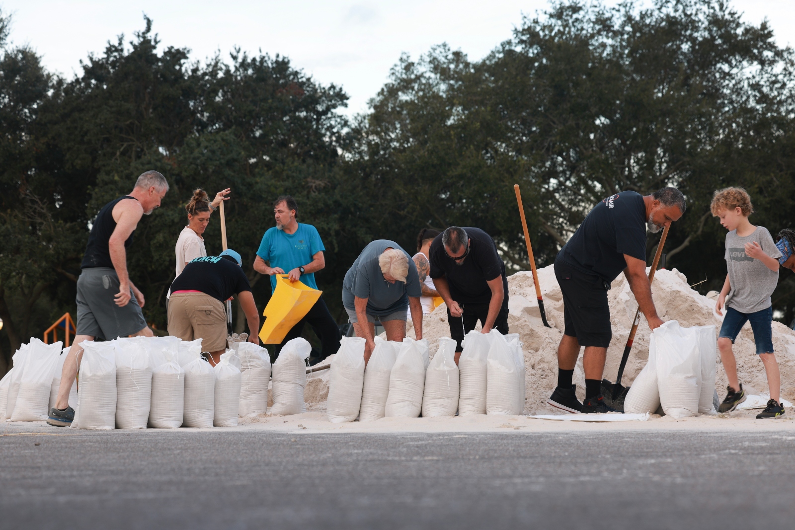
Photo by Joe Raedle / Getty Images
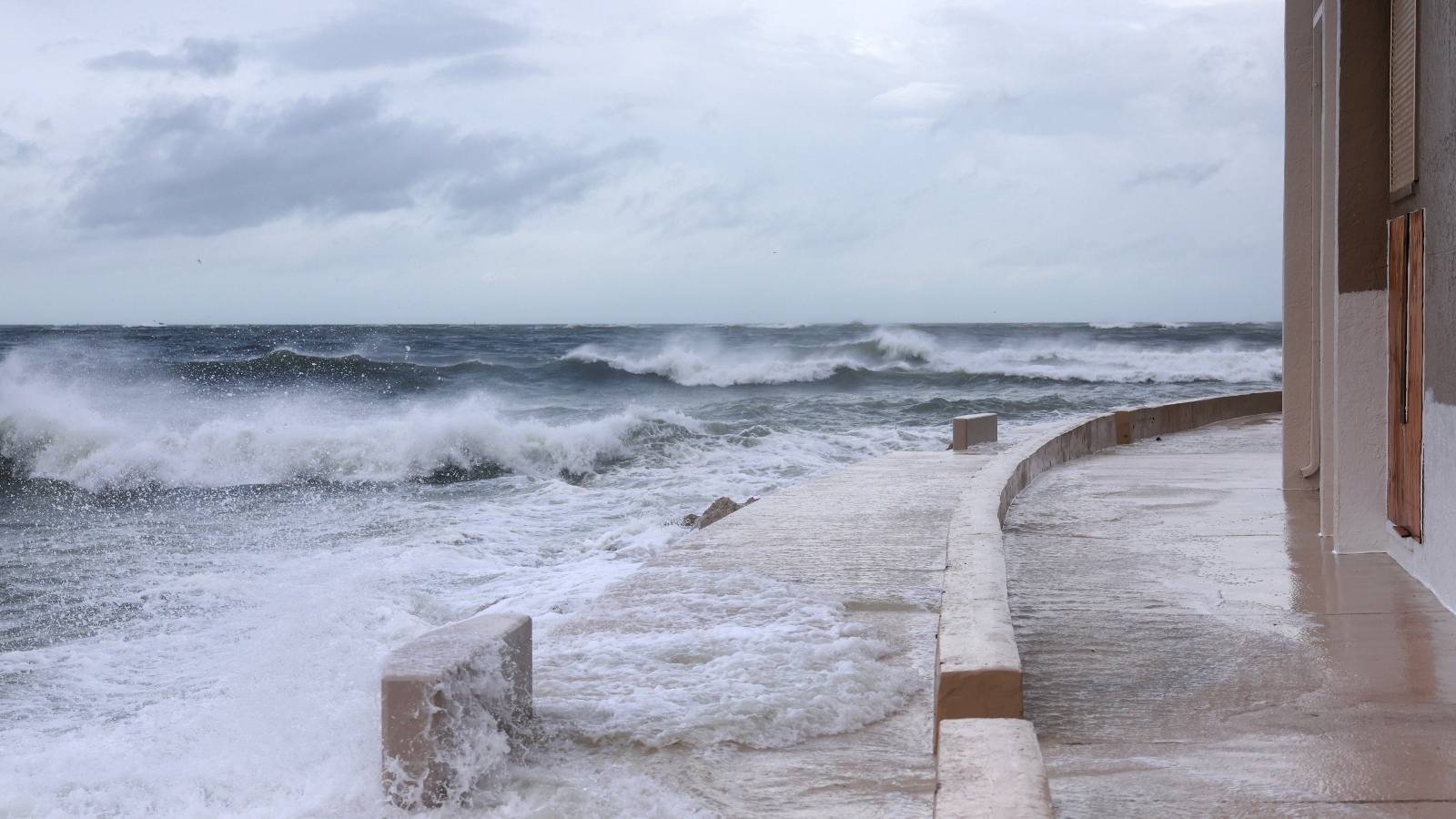
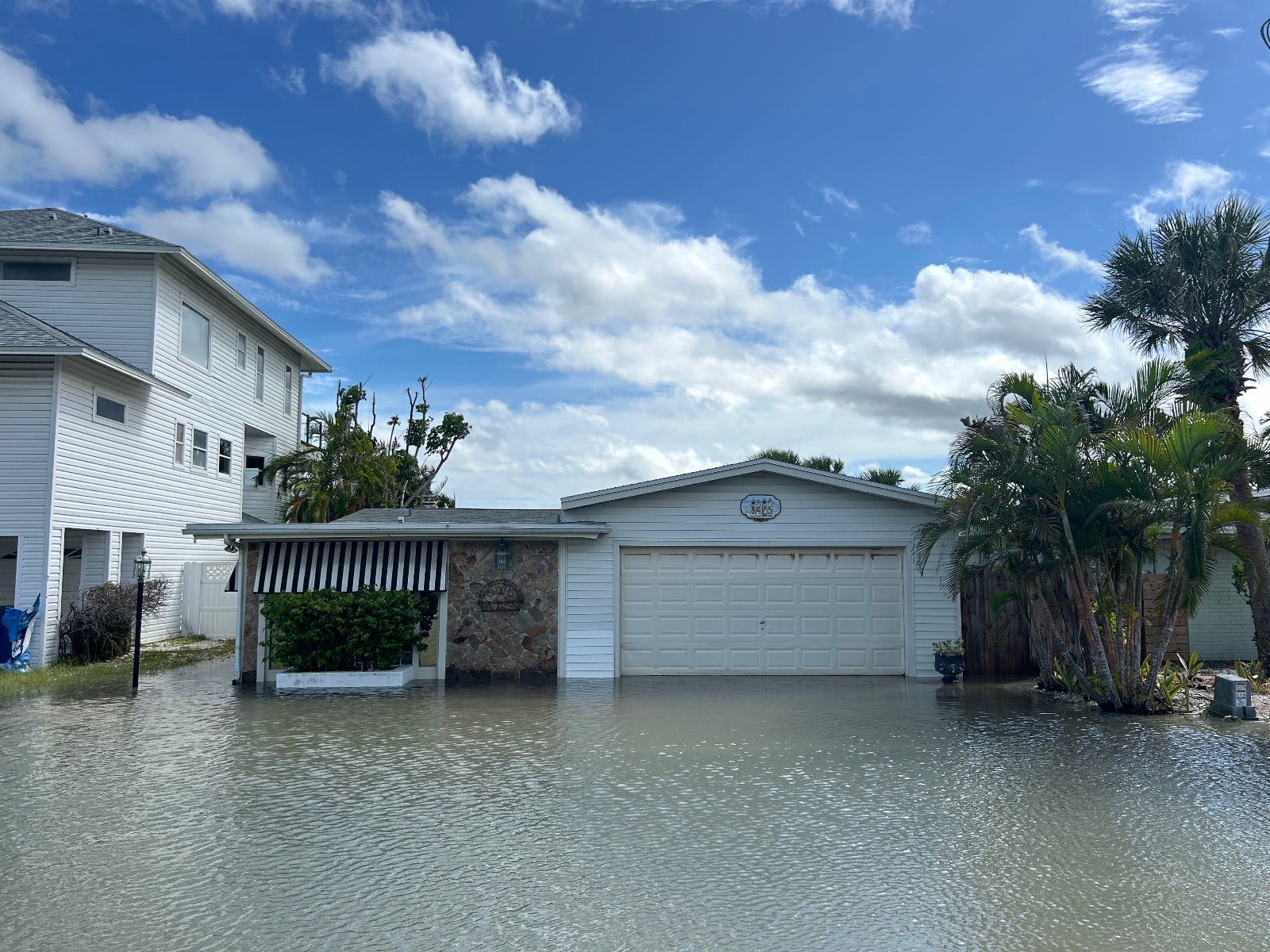
For communities on the coastline, what makes a storm like Helene so dangerous isn’t just the winds and rainfall, but also the storm surge. A hurricane’s winds bulldoze water ashore — a perilous outcome for a region like the Gulf Coast, which is already experiencing sea-level rise.
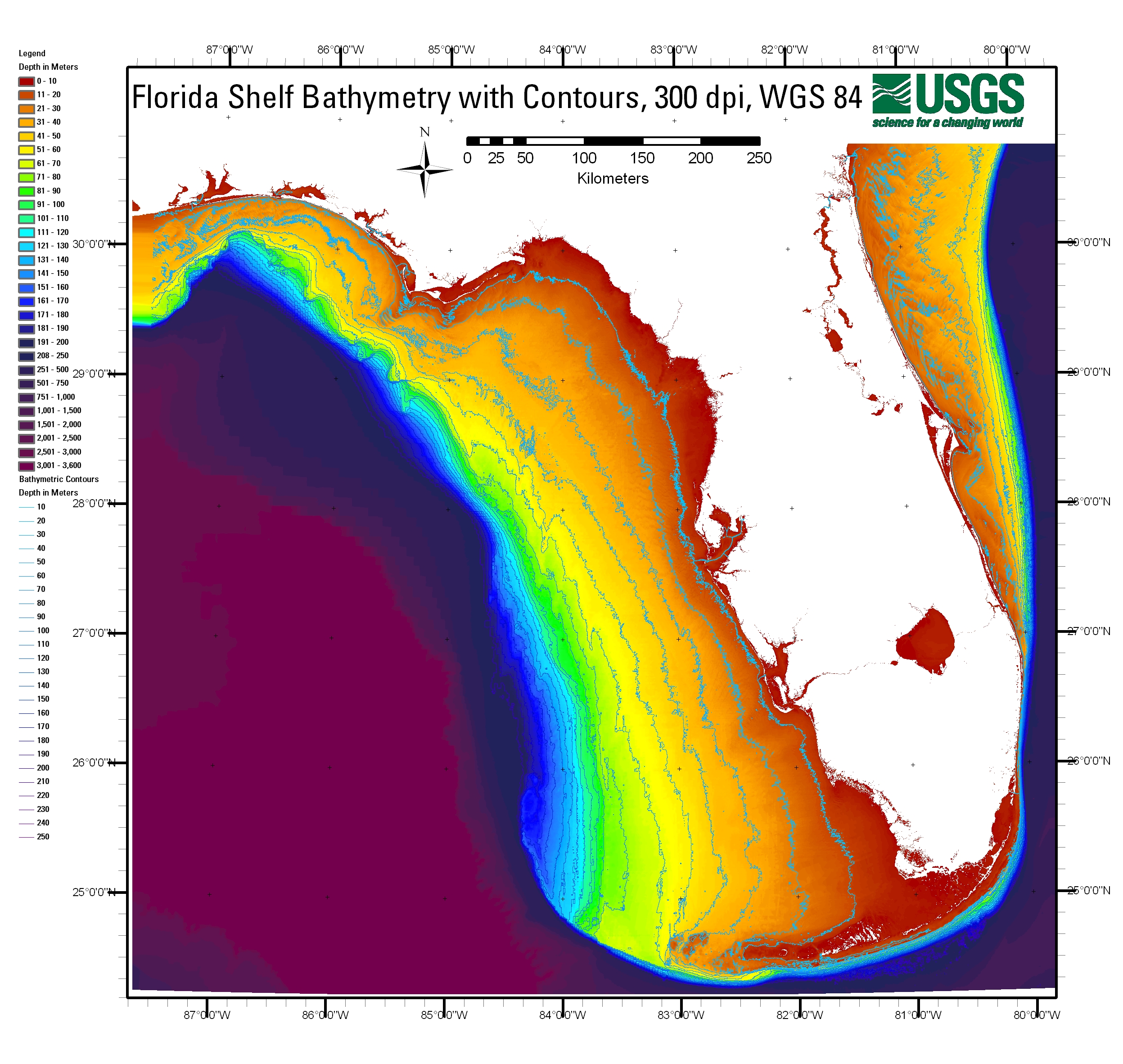
The geography of Florida’s west coast makes things all the worse. While the ocean depths of some beach regions drop precipitously right off the coast, here the depths increase gradually as you move away from shore. If the water near shore were deeper, a storm surge could partly be absorbed by these depths, attenuating its impact on land. But with such shallow water off of Florida, the water has nowhere to go but straight into coastal communities.
Even though the eye of Helene is projected to make landfall Thursday night around Tallahassee, a hurricane’s strongest winds tend to blow in the northeast part of the storm. For Helene, those winds are poised to hit Florida’s less-developed Big Bend region, which also suffered the worst impacts from Idalia last year. That part of the state is extremely low-lying, so the storm surge could rush inland unimpeded by the kind of geographic features that would normally be mitigating factors. The projected surge could reach as high as 20 feet in towns like Steinhatchee, just south of where Hope Webb is riding out the storm at her beachfront home. In an announcement Wednesday night, the National Weather Service office in Tallahassee called these conditions “catastrophic” “potentially unsurvivable.”
Farther south, the populous Tampa Bay region is also poised to see record surge figures after decades of near misses. “Just the shape of that coastline in that area, it definitely makes it unfortunately easier for that storm surge to pile up,” said Samantha Nebylitsa, who studies hurricanes at the University of Miami. “It sort of funnels into Tampa Bay, and so there’s really nowhere for the water to go but into that area.” In many cases, estimates suggest that Hurricane Helene is set to break surge records by more than 2 feet.
As of early Thursday, the storm was still hours away from passing over St. Petersburg, but winds had already begun to pick up and the sky was darkening. Several gas stations in the city’s downtown ran out of fuel as residents filled up their tanks, and most people in low-lying areas had fortified their homes against flooding with sandbags, tarps, or door sealants. Flashing signs that read “HIGH WATER EXPECTED” warned drivers to stay away from the coastline. Counties all the way down the Gulf Coast, including those that include the cities of Tampa and St. Petersburg, had issued mandatory evacuations for residents in storm surge zones and those who live in mobile and manufactured homes. Streets in the beach city of Clearwater were already seeing local flooding.
Jake Bittle / Grist
Hurricane Helene is a massive storm — its wind field is more than 400 miles across — so its rain will fall from the coastlines of Georgia and the Carolinas clear across to Missouri and Arkansas. As of early Thursday, every county in South Carolina, Georgia, and Tennessee was under some kind of flood or wind warning. Forecasters are warning of flash flooding, especially in the mountainous regions east of Knoxville and Chattanooga, Tennessee, as the storm stalls, and of dangerous wind that could cause widespread power outages through Georgia.
Like a car accelerating to a higher speed, Hurricane Helene can coast farther inland without running out of momentum, given just how much speed it has picked up as it has passed through the extra-hot Gulf waters.
“It’ll essentially just slingshot itself into those states,” said Nebylitsa. “And with that speed, it’ll take a lot more for it to slow down.”
All these regions, whether coastal or inland, have substantial development that is uniquely vulnerable to flooding. The Florida coast contains thousands of homes on low-lying coastal land that is easy prey for storm surge, and states such as Georgia and North Carolina have built thousands of homes near rivers and streams that are likely to flood when Helene passes over. As intense hurricanes like Helene get more frequent, they’re exposing these vulnerabilities.
“We’re entering this new normal of what we’re going to be experiencing under climate change,” said Michelle Meyer, director of the Hazard Reduction and Recovery Center at Texas A&M University. “But second to that, what’s been going on for a long time is that we continue to build in really risky places, in ways that are also pretty risky. So if we continue adding and adding more homes in areas that are going to flood regularly, or adding more homes on the coast without requiring greater mitigation, we’re going to continue seeing higher and higher dangers.”
Ayurella Horn-Muller contributed reporting to this article.