SIOUX FALLS, S.D. (KELO) — We’ve hit the halfway point of 2024, and we will likely be starting it off with some active weather this evening.
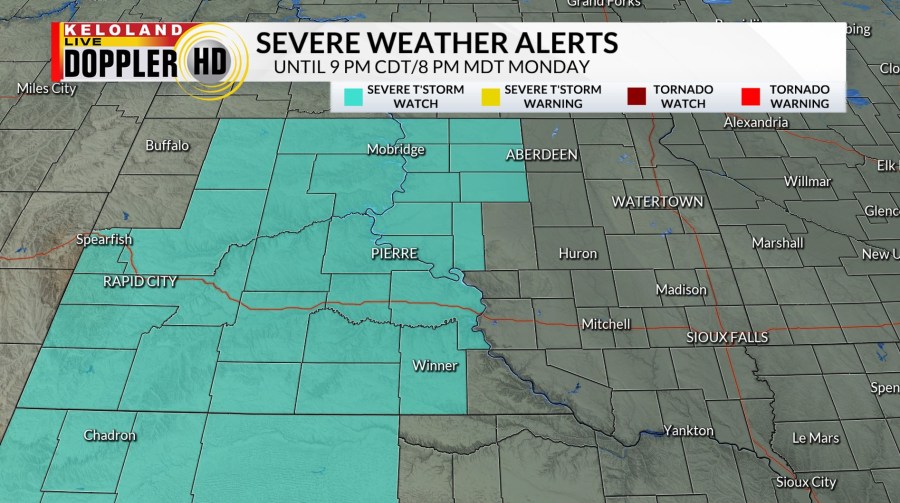
A severe thunderstorm watch is in effect until 9 pm CDT/8 pm MDT Monday for central and western portions of KELOLAND. Gusty winds, large hail, and an isolated tornado risk are possible.

This comes as a frontal boundary pushes eastward through the evening and interacts with an unstable airmass over western KELOLAND due to more daytime heating. Stay weather aware through the evening if you have outdoor plans.

Showers and storms will continue to push eastward into the night, with northeastern KELOLAND likely seeing some storms after sunset. To the southeast, a second piece of energy will come up from Nebraska and give that part of the region a chance at moderate to heavy rain and some storms as well.
Showers may linger into Tuesday morning, but it looks like the afternoon should be mainly quiet overall. Much of Wednesday is also quiet if you’re East River, but the western part of KELOLAND may see more action in the afternoon that spills eastward later into the evening.

A “Marginal Risk” for severe weather is in place for the western half of South Dakota through the evening and into the night.

The 4th of July outlook is, unfortunately, also looking unsettled from here. Scattered showers and thunderstorms are expected as we go into the afternoon and the evening as well. Please keep an eye out for updates if you have any outdoor plans. Some of those storms may also produce heavy rainfall at times.

Some showers and storms will linger on Friday before we quiet down by Saturday. With that said, though, the weekend still has the chance to see some pop-up showers and storms in a few areas.
We’ll try to quiet down again and warm up as we head into next week.
Here’s a look at your extended forecast: