SIOUX FALLS, S.D. (KELO) — Southeastern KELOLAND was able to squeeze in one more warm to hot and humid day before we start to get a change in place. For a majority of the rest of KELOLAND, we already got a preview of what’s to come.
Once the rest of today’s showers exit the region, we should be in for a mainly quiet night with partly to mostly clear skies attempting to take over. The key word is “Attempting”, since we’re not going to completely shake the clouds out of here any time soon.
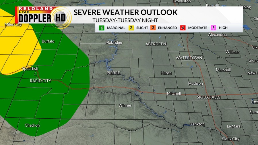
While Tuesday is mainly dry to the east, some showers and a few thunderstorms are possible out west. A few of the storms out that way may become strong to severe.
A “Marginal Risk” for severe weather is in place for a good portion of western South Dakota in green, with a “Slight Risk” in yellow toward Spearfish and Belle Fourche. Damaging wind gusts are the main concern with a secondary hail threat. If you have outdoor plans, including anyone attending Sturgis, please keep an eye on the skies and stay weather aware.

Chances for showers and storms increase for both sides of the river on Wednesday as our next system moves through the region. East River, this will be our best chance for rain through the rest of the forecast.
We’ll also have a “Marginal Risk” again for severe weather in western KELOLAND.

In its wake, we’ll have some lingering rain on Thursday to the west, but everyone gets in on another change: Cooler temperatures.
We dry out for Friday and much of Saturday, with both days also featuring temperatures that will be 5 to 10 degrees below average for this time of year in many locations.
Rain chances return by Sunday with better chances overnight on Sunday. We’ll dry out again for the start of next week.
Here’s a look at your extended forecast:


