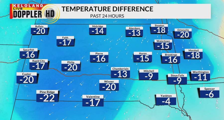
SIOUX FALLS S.D. (KELO) — It has been a much cooler day across KELOLAND with temperatures dropping over 20 degrees for some areas in the last 24 hours! Although this is a big drop, we have returned to seasonable temperatures with highs mainly in the upper 60s to lower 70s.

Breezier conditions behind the cold front that passed through will calm down into the evening. It will be a quiet night with cloud cover sticking around and lows dropping into the 40s.

Heading into tomorrow, sunshine will return for most of KELOLAND and highs will get back to above-average in portions of South Dakota. Winds will pick back up in West River as a cold front moves through again, creating elevated fire weather conditions.

After tomorrow, much cooler air returns as a trough digs into the Great Lakes region with temperatures falling back into the upper 50s to mid 60s. Frost and freeze conditions are likely on Monday and Tuesday morning with lows getting into the upper 20s and low 30s.

With the big changes in temperatures, unfortunately our precipitation chances have not been changing. Our drought conditions continue to worsen as portions of KELOLAND have been expanded to severe drought, while far western South Dakota struggles with extreme drought conditions.

We will continue our dry stretch going into the weekend and early next week. Temperatures will begin to warm up heading into the middle of the week with a chance of rain by the end of the week.
