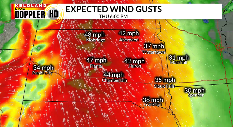
SIOUX FALLS S.D. (KELO) — With temperatures feeling “summer-like” across KELOLAND today, many are dealing with strong winds. Wind gusts have almost been near 50 mph in central South Dakota and that looks to continue heading into the rest of this afternoon and evening.

With the mix of strong winds and low relative humidity, this creates dangerous fire weather conditions for western and central South Dakota. The Red Flag Warning, along with Wind Advisories continue until later this evening.


As a cold front begins to move through, it will bring the chance for isolated showers and thunderstorms in western South Dakota for this afternoon and evening. There is a marginal risk, along with a slight risk in northwestern Harding county for severe weather. Any storms on the stronger side may contain gusty winds and hail.


Going into tonight, winds will turn to the northwest behind the cold front and calm down. Areas ahead of the cold front will keep the breezy, southerly winds heading into the overnight hours as lows stay mainly in the 50s West River and 60s East River.

Heading into the start of the weekend, it will be slightly cooler and dry behind the front in western South Dakota. For those East River, rain chances will increase as the trough and front move to the east throughout the day Friday. Winds tomorrow will be weaker than today, but still breezy. Temperatures will remain above average heading into next week with more rain chances.

