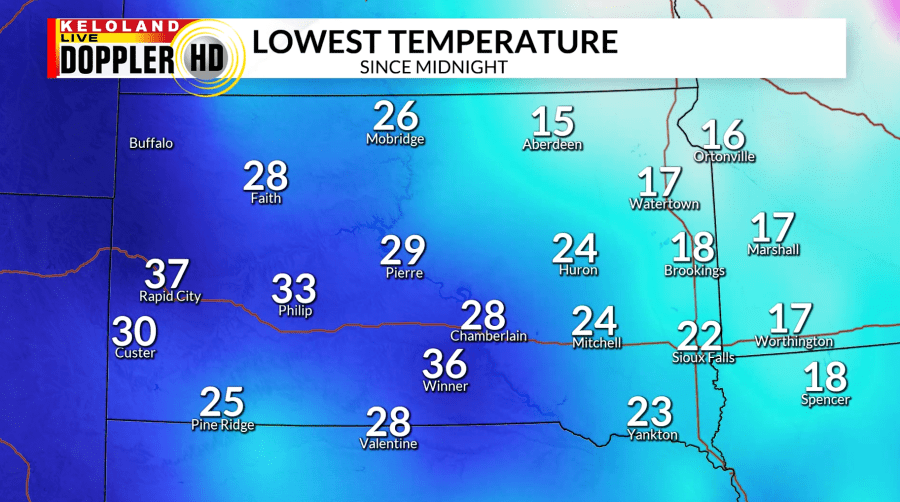
SIOUX FALLS, S.D. (KELO) — It was a quiet night across KELOLAND, with lows in the teens to the east and getting into the 30s in western South Dakota. Winds stayed on the calmer side but will begin to pick up heading into the day.

The southerly winds will help us reach well above average highs in the 50s and 60s. Cloud cover will start to increase from west to east as a cold front passes with a low pressure system moving to our north.

Rain showers are possible across KELOLAND going into the evening hours. A mix of rain and snow is possible out towards the Rapid City area and in northeastern KELOLAND as temperatures cool during the night. Although we could use some moisture, any accumulation will be very light.

Lows tonight will stay mild for this time of year, especially in eastern KELOLAND. Winds will start to turn to the northwest behind the front and become stronger going into tomorrow.

The gusty winds will be widespread, with some of the stronger gusts in southeastern KELOLAND by the afternoon hours. As the low pressure system moves off to the east, winds will start to decrease by the evening.

Once the system moves out on Sunday, we will start to dry out going into the week. Temperatures will stay mild this week with highs getting into the 60s and 70s by Thursday. It will be even warmer for the start of next weekend across KELOLAND, but we will watch another low pressure system move into the Midwest with chances for precipitation.
