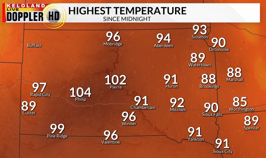
SIOUX FALLS, S.D. (KELO) — It has been another very hot day in central KELOLAND. High temperatures so far have been in the 90s and even a few triple digits. The wind has been stronger out of the south. There has been mostly sunny skies.

Then, adding the humidity, you get the heat index, or what the air feels like. Central and western South Dakota have heat index values very similar to the actual air temperature. Eastern KELOLAND is seeing higher humidity which means those heat index values are much higher than the air temperature.

Northeastern into south central portions of KELOLAND are under a Heat Advisory through this evening. The heat index values will stay near 100°. This area could be expanded, as well as the time extended into the weekend.

This afternoon and evening does have a risk of severe weather. This is a level 1 of 5, in green. Strong winds and small hail will be the main threats.

For tonight there will be thicker clouds in western South Dakota. We get rid of some of the wind overnight. The chance of thunderstorms in western South Dakota will continue overnight. Low temperatures will be on the mild end with lows in the upper 60s to low 70s.

Tomorrow is going to be another hot and breezy day. There will be partly to mostly sunny skies. High temperatures will be in the 90s across KELOLAND, so well above normal. There is a couple chances for rain and thunderstorms.

Some of those thunderstorms could become strong to severe by the afternoon and evening. This is a level 1 of 5 risk from south western into northeastern KELOLAND. Strong winds and large hail will be the main threats. There could be pockets of heavy rain associated with these storms.

Sunday looks to be about the same. High temperatures will be in the 90s across the area. There will be partly cloudy skies. The wind will stay stronger out of the south a majority of the day. There are more chances for rain and thunderstorms by the afternoon and evening.

Sunday afternoon and evening bring another chance of strong to severe thunderstorms. This is another level 1 of 5 risk. Hail and strong winds will be the main threats.

The temperatures remain hot as we head through the 7 day forecast. There are a couple more chances of isolated thunderstorms mid week. Sunshine and hot temperatures will stick around into the first weekend of August.
