From near 90 degree weather tomorrow to snow this weekend, another big swing in weather is headed for KELOLAND. Meteorologist Brian Karstens has a detailed look at the weather trends to watch in the video below.
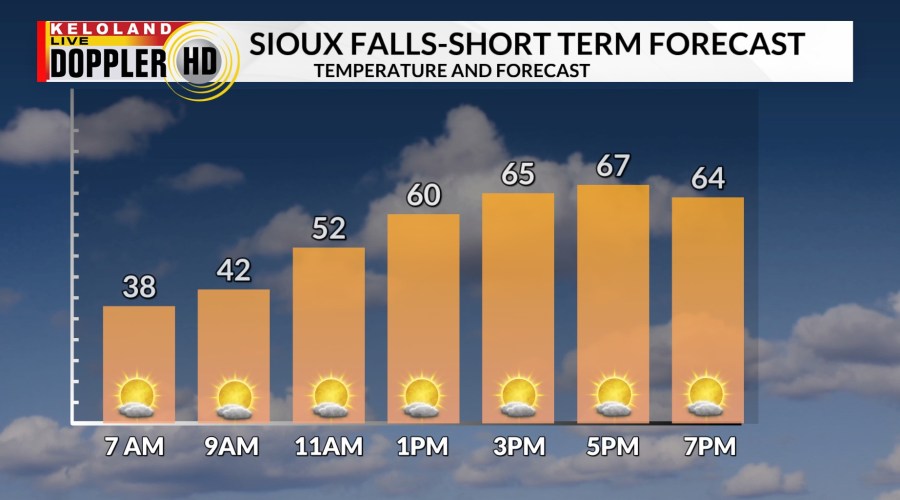
A pleasant forecast is ahead today in KELOLAND before the big swings in temperatures move into the forecast. The hourly forecast for Sioux Falls shows highs in the upper 60s this afternoon under a partly cloudy sky.

Tomorrow is looking much warmer in the southeast. Not only are daily record highs on the table for discussion, all-time records for March are within reach in the far southeast. Take a look at the video below for details. Our official high in Sioux Falls is 85. The all-time record is 88 for March, set back in 1943.
Another big story ahead is the chance for much-needed precipitation this weekend. Chances are increasing for a swath of .50″+ amounts coming into KELOLAND late Friday night into Saturday. The exact storm track could still expand and shift to the north, so continue to watch for updates today.

Watch the hourly forecast in the video below for details. All the warm air from Friday will quickly disappear as the rain and snow moves into KELOLAND on Saturday. We think Sioux Falls will stay rain during the day on Saturday, before mixing with snow Saturday night and Sunday AM. Notice the rain and snow line does include some of our northern counties as well. We are still watching the northern potential with this system as the data is still split on the verdict for Mobridge and Aberdeen. The bottom line is it will be wet day and a good opportunity for some much-needed moisture.
The best chance of accumulating snow will be NW of Sioux Falls. The snow will have the best chance to stick to the ground if it falls Saturday night. It will be heavy wet snow, but we are not forecasting overly strong winds. We think wind gusts of 20-30 mph can be expected on the back side of this system.

We won’t see much of a break before the next system arrives late Tuesday into Wednesday. This storm already looks similar to the first, so expect another round of rain to snow across the plains. And there’s even more to the story as we watch another active system emerging about a week out. The pattern is ripe for moisture opportunities and some drought correction.
Here are the details of the forecast.


