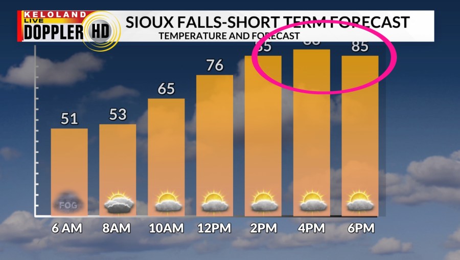
Record highs are the big headline today in southeastern KELOLAND. We are forecasting near 88 in Sioux Falls, which would tie the all-time record for the entire month of March. The daily record is 82, which should easily be broken. Notice our nice bar graph below is literally off the charts.

Red flag warnings for extreme fire danger have been posted for the southeast.

We will be tracking a cold front moving south across KELOLAND this afternoon. Temperatures will start cooling this afternoon in the north behind the front. Also, watch for isolated t-storms this evening just south and east of Sioux Falls. Any thunderstorms that do develop may produce some dry lightning and gusty winds. Rain will be the story on Saturday as embedded t-storms develop and move into southern KELOLAND. We also expect a rain /snow mix to develop in southwest and southcentral SD during the afternoon. Temperatures will be much cooler across the entire region.
This story system should produce areas of .50″ or more of precipitation across the south and the southeast. Folks in the far north will likely trend lower. I would not surprised if over an inch of rain occurs with some of these local thunderstorms tomorrow.

A coating of heavy wet snow is not out of the question Saturday PM into Sunday AM. This scenario may warrant some extra attention this weekend in southcentral KELOLAND, with a narrow band of snow potential extending northeast in the general direction of Watertown.

Here’s a look at the chances of getting a sloppy 3″ snow this weekend. Keep in mind, those that get some of this snow won’t see for long. It always melts fast this time of the year.

Here are the details of the forecast.


