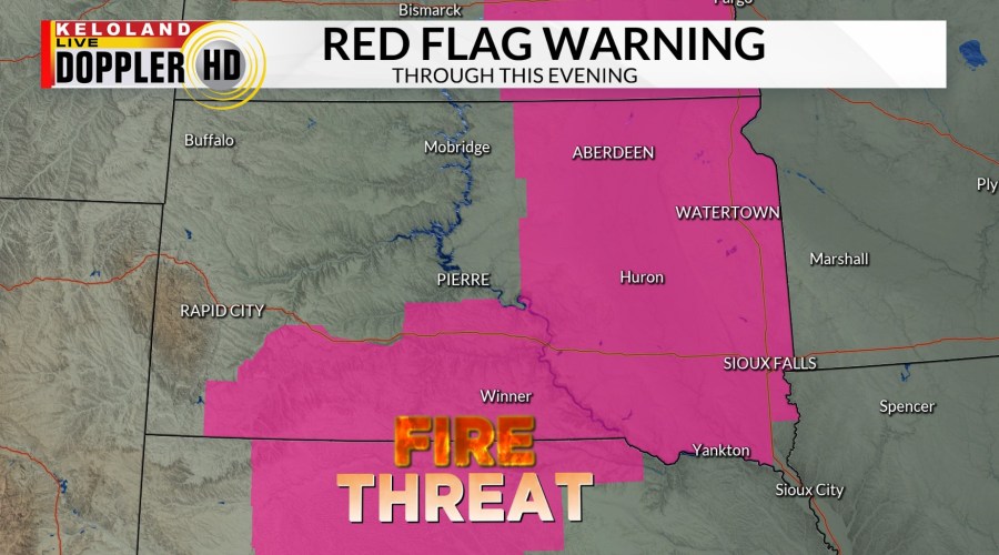
SIOUX FALLS S.D. (KELO) — A return to warmer temperatures and sunny skies will be a nice change, but it comes with a fire danger risk across much of KELOLAND. A Red Flag Warning has been posted for much of eastern and southern South Dakota through this evening.

The blizzard that tracked just south Sioux Falls yesterday packed a punch. Strong winds over 60mph combined with heavy wet snow to create white-out conditions. Several areas north of Omaha are still reported power outages this morning.
You can see the track of the snow on the map below.

As most of us know, the weather in March changes quickly and you can see that quick recovery in the Sioux Falls hourly planner below.

Futurecast shows the widespread mild weather today, but a fast-moving system will pull into the plains tomorrow morning. We expect some scattered showers (mixed with AM snow north) to move quickly across eastern KELOLAND during the day. The weather will then turn dry and warmer on Saturday before the next system arrives on Sunday. Showers chances look better Sunday morning, followed by stronger NW winds during the day on Sunday.
You can see the daily wind changes on the video below. The strongest winds should arrive from the northwest on Sunday.
While temperatures will go up and down with each passing front, temperatures will still average above normal into next week.
Here are the details of the forecast.


