8:30am Update-
8:15am Update–
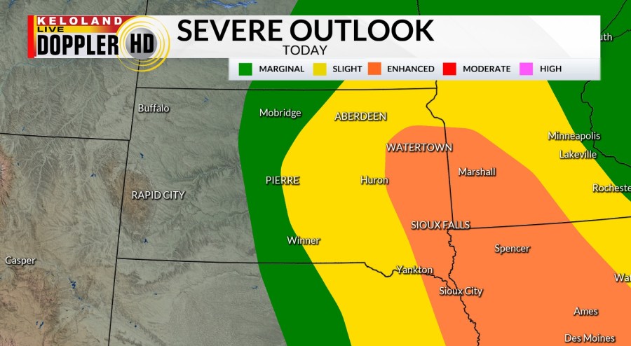
The Storm Prediction Center has just expanded the enhanced risk of severe weather to include Watertown, Brookings, and Marshall. The probability of more intense severe weather today and this evening is increasing. More details to come.

Severe weather is our top weather story today. Expect areas of storms to develop in northern South Dakota, with more development in the southeast after 2pm. Take a look at the radar picture as of 7:20 this morning.

Here are some of the weather conditions we will be watching.

The Storm Prediction Center has expanded the slight risk zone in yellow and has upgraded parts of the southeast to an enhanced risk, including Sioux Falls.

Here’s a closer look at that map. The main concern is that the storms in northern SD will take a right turn and plow into extreme instability near the Sioux Falls area by mid afternoon. We’ll be updating the likelihood of this scenario after 8am.

The upper air disturbance to support the severe weather is very obvious. You can see the low moving into NW South Dakota early this morning.

Watch this short video update recapping our top weather weather stories we are following.
You can also watch our Futurecast update below. We think storms can arrive in Sioux Falls after 2pm, but the timeline will be faster in Aberdeen, Huron, Brookings, and Watertown. Have a plan in place now if storms quickly approach your area.
Here are the details of the forecast.


