
April 1 has come and gone, and from here on out, it’s all downhill — literally and figuratively — for Nevada’s snowpack.
Snowpacks are Mother Nature’s reservoirs, natural repositories that slowly release water downstream into lakes, reservoirs and sinks. April 1 is historically the date in Nevada and across the Eastern Sierra that most snowpacks hold their highest water content.
It’s this water content — not just the amount of snow on the ground — that serves as a harbinger of what everyone from farmers to rafting guides to firefighters can expect in the coming year.
And this year was a mixed bag for Nevada.
While far Northern Nevada wrapped up the winter with above-median snowpack, Southern Nevada had what officials are calling an “abysmal” year. Western Nevada’s snowpack was about average, while pockets of eastern Nevada were exceptionally dry.
Those variable conditions were the product of a very dry January, followed by warm storms that often brought more rain than snow and a late March heatwave.
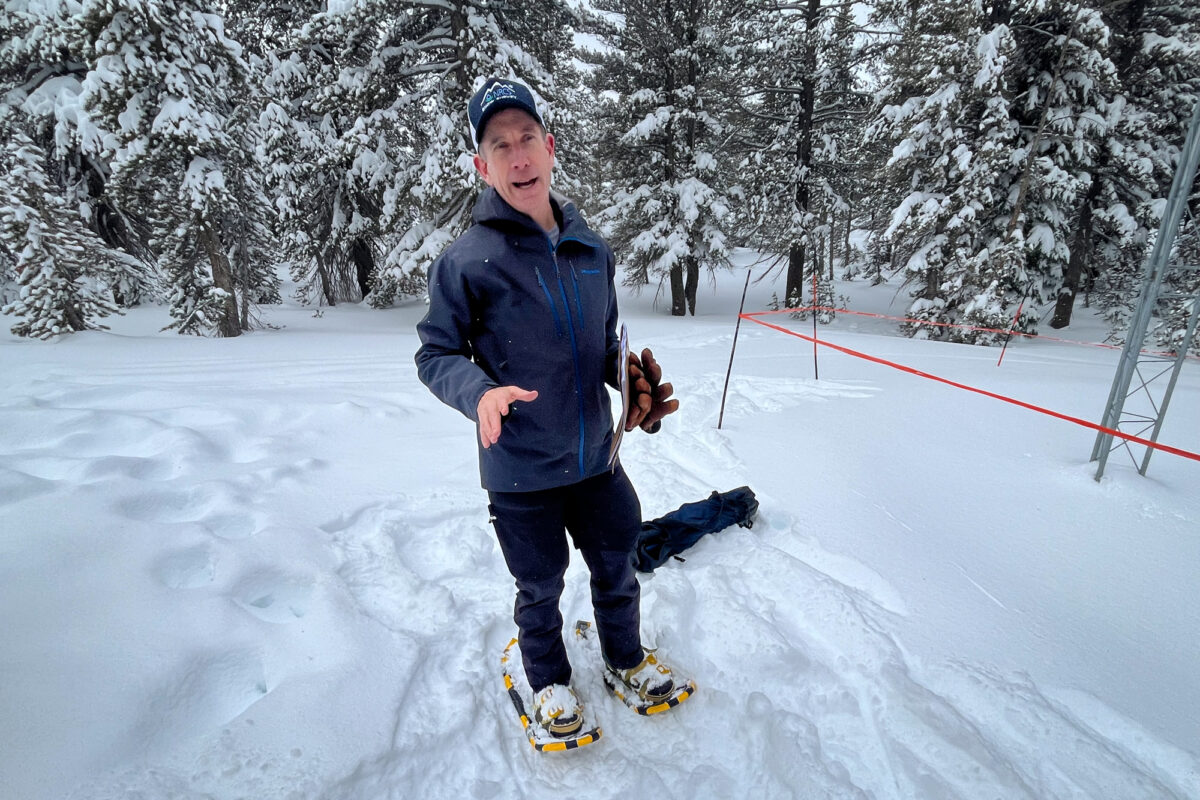
“For a lot of areas, that made it so we didn’t develop much of a snowpack,” said Jeff Anderson, state hydrologist for the U.S. Department of Agriculture’s Natural Resources Conservation Service.
Warm storms
It’s not uncommon to have warm winter storms, Anderson said. But this year, Nevada experienced its sixth-warmest winter between December and March, according to the National Oceanic and Atmospheric Administration, and the warmest since 2015.
And it was the fourth-warmest winter on record in the Sierra Nevada going back to 1895, according to Dan McEvoy, a researcher at the Desert Research Institute’s Western Regional Climate Center.
“We’re definitely on a long-term trend of warmer winters in general,” McEvoy said. That trend, combined with the state receiving most of its precipitation from atmospheric rivers that pull moisture from the tropics, “have led to generally warmer storms in the wintertime.”
Warmer winter storms caused mountain snowlines to sit higher while bringing rain to valley locations. As a result, the geographic extent of snow-covered areas is smaller this season, so although the April 1 snowpack looks similar to last year’s, the disparity in snow-covered areas could lead to different patterns of spring melts and streamflows.
“The gradient between the valleys at the lower elevations and the higher peaks has been particularly pronounced this year,” according to Baker Perry, the state’s climatologist.
Particularly notable across much of the West was an abnormally warm week in late March that led to record-breaking snowmelt.
Between March 21 and 27, the daily average high temperature across Nevada and the Eastern Sierra was nearly 48 degrees Fahrenheit — an average high the state had not seen since October.
A snow measuring site at Leavitt Lake, which sits at 9,600 feet and is the highest elevation snow measuring site in the Eastern Sierra, reached 50 degrees Fahrenheit on March 24. Great Basin National Park’s Wheeler Peak, the second-highest mountain in the state, has a snow measuring site at 10,070 feet that reached 55 degrees Fahrenheit on March 27.
With the warmer storms, the snowpack didn’t contain as much cold content, and it didn’t take much warmth to trigger snowmelt.
“Once that train starts rolling, it’s really hard to get it to stop,” Anderson said.
Statewide, an average of 2 inches of snow water melt was recorded that week, mirroring a larger issue: More snow is melting in the winter and early spring. Since 1950, snowpack has declined more than 25 percent across the West.
“There’s strong evidence there’s a climate change signal in some of this,” Perry said. “Storms get warmer, just like we saw this winter.”
In places such as Southern Nevada, which started the year with record-setting dryness and saw its limited snowpack melt out early, “that’s gonna have impacts for things like grazing and rangeland conditions, and there’s a lot of concern around elevated wildfire conditions,” McEvoy said.
Invasive plants at Cathedral Gorge State Park in eastern Nevada already pose a serious fire hazard, and bighorn sheep in Valley of Fire State Park have been hit hard by a lack of surface water. Plus, the Climate Prediction Center is calling for high evaporative demand between April and June, leading to even drier landscapes and vegetation.
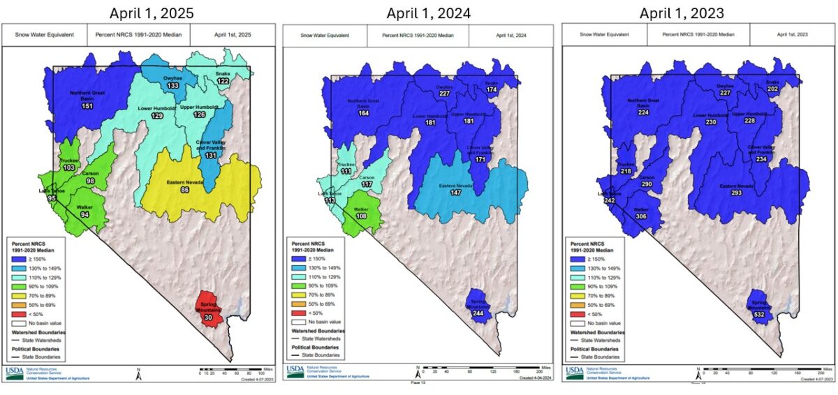
Breaking it down by region:
- Extreme Northern Nevada
- For the third consecutive year, the Humboldt Basin’s snowpack was above average. The region benefited from storms that tracked across Oregon and Idaho, leaving the region with snowpack levels between 122 and 151 percent of median.
- The last time the basin saw a better three-year period was in the mid-1980s.
- Lake Tahoe, Reno and Ely
- In Eastern Nevada, snow percentages increased from 55 percent of normal on March 1 to 86 percent by April 1. Last year at this time, Eastern Nevada’s snowpack averaged 150 percent of normal.
- In Western Nevada, basin snowpacks were around average.
- As of April 1, two-thirds of the state (primarily south of Interstate 80) was experiencing some level of drought.
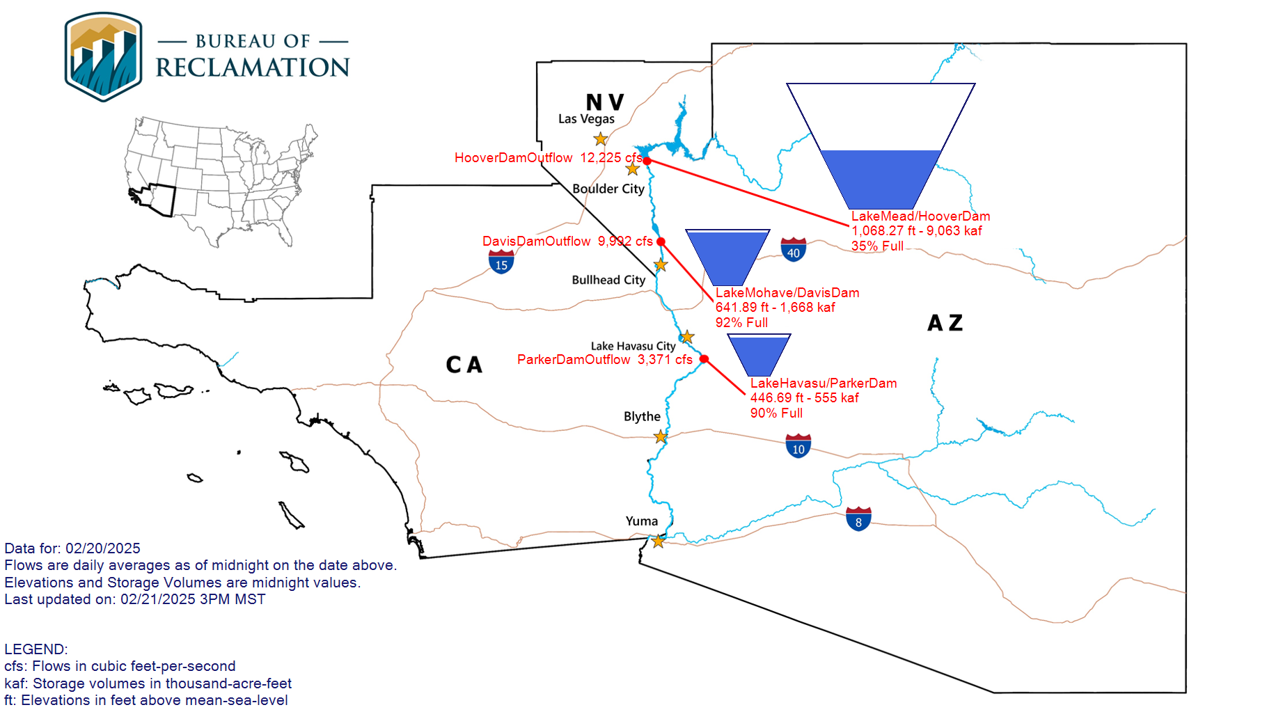
- Southern Nevada and the Colorado River Basin
- The Spring Mountains received less than one third of their usual snowpack and, by April 1, some of the state’s measuring sites in Southern Nevada were already free of snow. Las Vegas went a notable 214 days without measurable precipitation before breaking that streak in mid-February.
- Much of the Colorado River Basin didn’t fare well, either. While the basins along the headwaters of the Colorado River, the primary water source for Las Vegas, received 88 percent of their median snowpack, the Lower Colorado River Basin received less than half its usual snowpack.
- Lake Mead is only one-third full and, on April 1, Mead and Lake Powell jointly had 691,000 acre feet less water than the same date last year.
- Runoff projections from the National Weather Service’s Colorado Basin River Forecast Center show below-average flows over the winter into Lake Powell, which feeds Lake Mead, with predictions of about two-thirds the normal amount flowing into the reservoir, an amount McEvoy said isn’t “that really massive runoff you need to boost reservoir levels.”
- And, Anderson cautions it could get worse. “If it turns out to be a dry spring, it won’t even be that,” he said.