SIOUX FALLS, SD (KELO) — Good morning KELOLAND! We are starting the day cold in much of the region, with temperatures near -11 below zero in Pierre as of 6:30am. That’s cold! The fresh coating of snow is giving that cold air some extra strength in central SD. We also have slick roads in these areas, so slow down for the conditions.
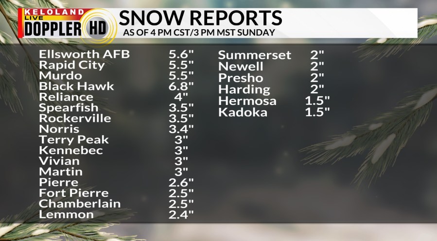
Snow reports have been heaviest around Rapid City over the weekend, where over 5″ of snow has been reported. You can see some of the other numbers in the graphic below.

Portions of Kansas and Missouri were hit hard by snow and ice over the weekend. You can see the path of the heaviest snow on the map below.

No big snow is in our forecast, but some light snow or flurries can be expected the next 24 hours, mainly west of Sioux Falls. Temperatures today will hold in the teens for highs with single digits both above and below zero tonight. More cold air will pour into KELOLAND tomorrow, keeping temperatures once again below normal for this time of the year.
We do expect a warming trend by Thursday along with a chance of either light snow or light mixed precipitation. Highs should return to the 30s, with more above normal temperatures forecast this weekend. However, there could be some chances of light snow returning as well, a trend we’ll keep watching. There could also be some windy weather on Saturday. We’ll want to see a crust on that new snow in western SD between now and then.
New snow chances later this week look much better way to our south. Take a look at the snow potential for northern Texas and Oklahoma later this week!

The temperature trend map looks interesting as the coldest temperatures compared to normal will be mainly south of us. Meanwhile, much of Canada will trend above normal the rest of the week.
Here are the details of the forecast.


