Drought conditions across America’s western states are being replaced by “abnormally wet” weather, according to US government scientists, with almost half of the US forecast to flood over spring.
“Moderate to exceptional” drought coverage across the US has hit its lowest level since August 2020, with both wet and dry extremes being driven by climate change, according to the National Oceanic and Atmospheric Administration’s Spring Outlook.
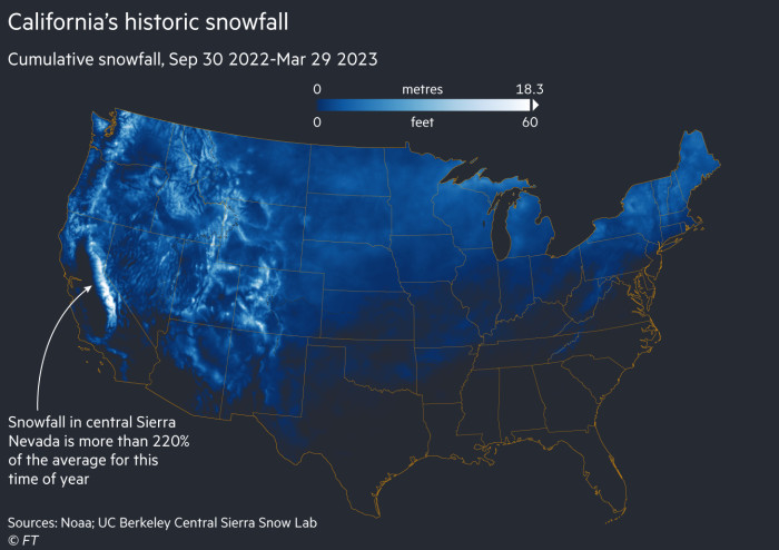
In California, a series of powerful Pacific storms combined with heavy snow wiped out “exceptional” and “extreme” drought in the state for the first time since 2020.
But scientists said 44 per cent of the US was at risk of flooding over the spring. Affected regions include “most of the eastern half” of the US, including major flooding along the Mississippi River from Minneapolis, Minnesota to St Louis and Missouri.

California, where an unusually large snowpack has accumulated in the Sierra Nevada mountains over the winter, is also at risk of flooding as the snow melts, said NOAA.
The water could help reverse record-low reservoir levels in the Colorado River Basin, where an enduring “megadrought” has driven water levels in America’s two largest reservoirs to record lows.
Last year, water levels on Lake Mead, the largest US reservoir, and Lake Powell upstream on the Colorado River dropped sharply, prompting federal officials to activate an emergency drought plan. Water levels on Lake Powell were the lowest since it was filled in the 1960s.
Earlier this year, US government climate scientists said more than half the country is enduring drought conditions, while a separate study estimated that the drought affecting southwestern states was the worst to hit the region for 1,200 years after being exacerbated by human activities that have raised average temperatures.
Climate change was driving both wet and dry extremes in the US, said NOAA administrator Rick Spinrad. Earlier this month, US government scientists declared the latest La Niña weather event. The phenomenon involves the large-scale cooling of the Pacific Ocean’s surface, which drives changes in wind and rainfall with consequences across the globe.
Typical effects of La Niña have included unusually dry conditions in parts of the US and South America, as well as abnormal amounts of rain and more frequent cyclones in countries such as Australia. New South Wales, its most populous state, experienced its wettest ever November since records began 121 years ago.
Scientists have predicted neutral conditions — representing a transition period between La Niña and El Niño, which warms Pacific Ocean surfaces — would “likely” continue into early summer.
Drought is also expected to linger in some parts of the US, including some northwestern states and the northern Rockies region, while parts of Washington state may enter into drought.
Climate Capital

Where climate change meets business, markets and politics. Explore the FT’s coverage here.
Are you curious about the FT’s environmental sustainability commitments? Find out more about our science-based targets here


