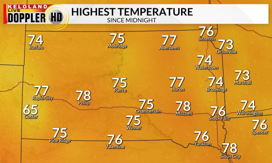
SIOUX FALLS, S.D. (KELO) — Temperatures this afternoon have been on the cool side. High temperatures are slightly below normal, in the mid to upper 70s. The wind has been mostly light. We are tracking a few thundershowers across KELOLAND. These are not expected to become severe and should die down by sunset.

We will have partly cloudy skies for the overnight hours. The wind will stay light. Low temperatures will drop into the 50s and low 60s. There will be another round of thunderstorms picking up overnight in central and western South Dakota.

Tomorrow will be a couple of degrees warmer. High temperatures will be in the upper 70s to low 80s. The winds will stay mostly light. We could have morning rain and thunderstorms. Those will clear out for a mostly quiet start to the afternoon. We are keeping an eye on the chance for afternoon and evening thunderstorms that should clear out after sunset.

There is a risk of severe weather tomorrow afternoon in south central and southeastern KELOLAND. This is a level 1 of 5 risk. Large hail and strong winds will be the main threats.

Sunday will be a touch warmer than Saturday, except in western South Dakota. Western South Dakota will have a stronger wind out of the north helping hold the temperatures down. There are a couple more chances of rain and thunderstorms on Sunday.

The skies will dry out starting on Tuesday. The sun will stick around for the work week helping warm temperatures up. By the end of the week and into the weekend temperatures will be in the mid 80s to mid 90s.
