CNN
By Mary Gilbert, CNN Meteorologist
(CNN) — Summer technically starts next week and will show the US what it’s capable of in a world warming due to fossil fuel pollution and without El Niño.
Prolonged, record-breaking heat is on the way for an area of the country that has largely avoided it so far, wildfire risks are rising in parts of the West and bathtub-warm water could fuel the first tropical depression of the Atlantic hurricane season.
Heat dome to bring intense heat wave for millions
Heat arrived in the eastern half of the country Friday, but it’s just an appetizer of what’s to come.
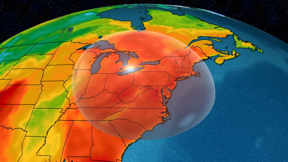
An expansive and exceptionally strong heat dome builds Sunday over the East and expands to reach the Midwest and Great Lakes over the following days, ushering in the regions’ first significant heat wave of the year. Heat domes trap air in place and bake it with abundant sunshine for days on end, making each day hotter than the last.
This one will make temperatures skyrocket to levels hotter than even the hottest typical summer day.
Hundreds of temperature records could fall by the end of next week, both during the day and at night.
Temperatures will top out 15 to 20 degrees above normal over a huge portion of the eastern half of the country Monday afternoon, but surge even higher to reach 25 degrees above normal at times from Tuesday through Friday.
This translates to days of high temperatures well into the 90s for tens of millions of people who don’t typically bake in long-lasting heat.
Relief from the heat won’t be found at night, which is another symptom of a warming world. Overnight low temperatures aren’t expected to drop below the low 70s or upper 60s in many locations.
To make matters worse, humidity will work in tandem with extreme heat to send the heat index – how heat feels to the human body – to dangerous triple digits in parts of the East. Heat index values in the low 100s are possible as far north as Maine next week.
The health risks from heat will reach extreme levels for millions next week, according to a scale from the National Weather Service and CDC. Heat is the deadliest form of weather in the US, killing more than twice as many people each year on average as hurricanes and tornadoes combined.
First signs of tropical trouble are brewing
The Atlantic hurricane season looks ready to awaken at the same time intense summer heat bakes a significant portion of the country.
There are two short-term risk areas that could produce the first tropical system of the year, and both are a little too close to the US coast for comfort.
An area in the southwestern Gulf of Mexico has the highest chance to become the first tropical system. There is also a small window and a low chance the same stormy pattern driving Florida’s rain could develop into a tropical depression off the Southeast coast before it gets swept out to sea this weekend.
Robust tropical moisture is swirling in the southwestern Gulf because of the Central American gyre: A large, disorganized area of showers and thunderstorms that rotates over Central America and its surrounding waters.
The gyre’s broad spin and abundant moisture can help tropical systems form in parts of the Caribbean, the Gulf of Mexico and even the extreme eastern Pacific Ocean when other necessary factors – including favorable upper-level winds and warm ocean water – align.
That could be the case by midweek; the National Hurricane Center says there’s a medium chance a tropical depression could form in the Bay of Campeche in the southwestern Gulf. Most of the Gulf of Mexico is bathtub-warm, so if a tropical system manages to form it would have plenty of fuel to strengthen. If something does form, it’s likely to track north or northwest.
Regardless of tropical development, a surge of moisture like the one behind the deluges in South Florida will provide much-needed wet weather to parts of Mexico that have been baking under extreme heat and brutal drought for weeks.
But it will also raise the flood risk along the Gulf Coast, especially in areas soaked this spring.
Multiple days of rain are heading for the Gulf Coast from Texas to Alabama starting Sunday and continuing throughout the week.
Wildfire risk growing
Heat isn’t just making us sweat and giving hurricane season a boost – it’s also had a hand in several recent notable wildfires.
Fire activity is increasing gradually nationwide, according to the National Interagency Fire Center. Almost a dozen large fires are burning in parts of the West and half of these started in recent days.
Hot, dry conditions in place since early in the month in the West will continue to increase wildfire risk and could worsen ongoing fires. Wildfire fuels like grass and plant life will continue to dry out during this time, making them more prone to fire ignition or spread.
Winds will also kick up in the region later this weekend and early next week. Gusty winds cause wildfires to spread quickly, as the Corral Fire demonstrated in California at the start of June.
Breezy conditions could also spell trouble next week for a small, but destructive fire in Arizona, about 70 miles northwest of Phoenix, dubbed the Rose Fire.
The fire destroyed at least 15 structures – seven of which were homes – along with at least a dozen vehicles, the Arizona Department of Forestry and Fire Management said Thursday.
The fire had burned through at least 166 acres since igniting Wednesday, but was only 20% contained as of Thursday evening.
CNN’s Paradise Afshar contributed to this report.
The-CNN-Wire
™ & © 2024 Cable News Network, Inc., a Warner Bros. Discovery Company. All rights reserved.

