SIOUX FALLS, S.D. (KELO) — It was another week with dry conditions. In fact, some have been dry for over two weeks as the drought monitor continues to worsen.
With sunshine again Thursday, temperatures warmed to the 80s and low 90s. Some set or got close to record highs. Even with a series of cold fronts for this weekend, we’ll stay dry. The dry conditions continue to take their toll on the drought monitor.
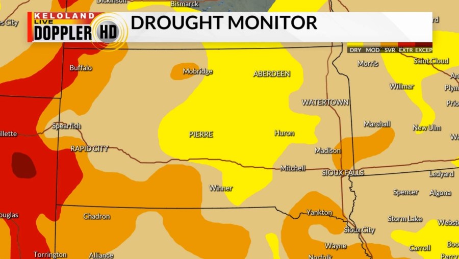
Here’s the latest look at the drought monitor.

First of all, all of KELOLAND is in some sort of drought.
Conditions in western South Dakota are the worst with the severe to extreme category. South central South Dakota is also showing the severe category expanding.
And drought continues to expand in eastern KELOLAND.
Extended models are at least giving us hints of a rain chance late next week. Most of this is showing up in eastern South Dakota and Minnesota. Proceed with caution, as I’m worried as to how much moisture will be available.
As temperatures warm well above average late next week, hopefully, the moisture will follow. Unless I see better data, I wouldn’t be surprised if it ends up being one of those days where the radar is showing rain, but a lot or all of it isn’t hitting the ground because of a dry atmosphere.