SIOUX FALLS, S.D. (KELO) — It’s a cooler morning across KELOLAND with temperatures in the low to middle 50s. Many are waking up to mostly clear skies and light winds.

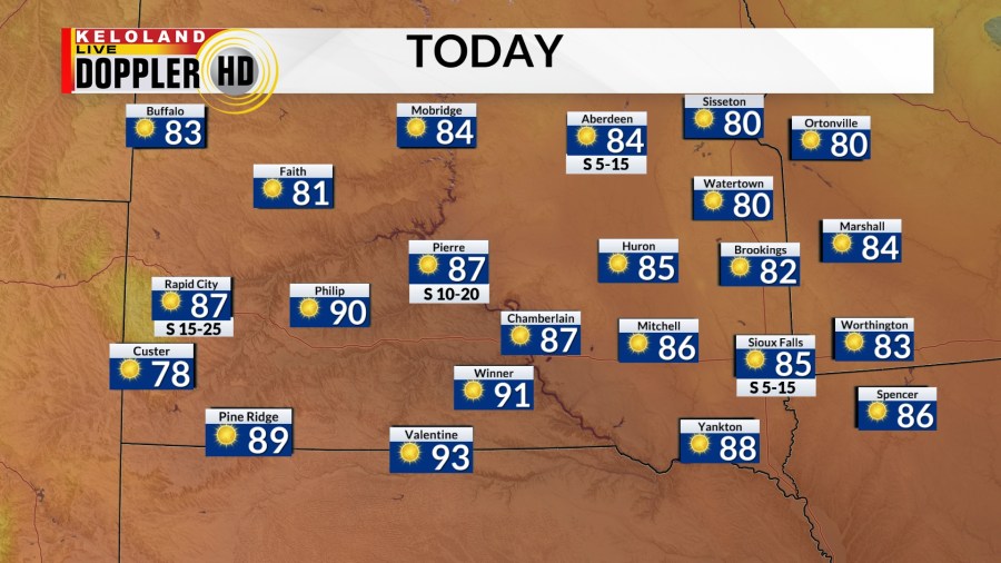
Today will be warm. Expect increasing southerly winds to help temperatures to the 80s and low 90s. Low 90s will be found in south central South Dakota.

There is an isolated chance for a shower or thunderstorm in northeastern South Dakota tonight. We have it in the forecast at 20%.

In the meantime, expect partly cloudy skies. Temperatures will fall to the 50s and low 60s.

The first half of the weekend will be warm in southeast KELOLAND, but expect much cooler air to move into western, central, and northern South Dakota. Highs will range from near 80 in the southeast to the 60s in the west. Strong northwest winds will be behind a front for western South Dakota to help bring in the cooler weather.

Futurecast has a slight chance for rain during the afternoon in southeast KELOLAND.
Everyone will be cool on Sunday. Highs will reach the 60s to near 70°. This happens with a mostly cloudy sky in the southern half of the area to to partly cloudy skies in the northern half. We’re also watching for rain a slight chance of rain in south central and southeastern KELOLAND.

Take whatever rain you can. Next week is looking dry with moderating temperatures. Expect afternoon highs to reach the middle to upper 70s by midweek.